Hudson Waterfront
The municipalities comprising the Hudson Waterfront are Bayonne, Jersey City, Hoboken, Union City, Weehawken, West New York, Guttenberg and North Bergen in Hudson County and Fairview, Cliffside Park, Edgewater and Fort Lee in Bergen County.
To the east lies the New York City boroughs of Manhattan and Brooklyn, to the south Staten Island, to the west Newark Bay and the New Jersey Meadowlands and to the north Northern Valley and the Palisades Interstate Park.
[2][3][4][5][6] Fort Lee, in Bergen County, opposite Upper Manhattan and connected by the George Washington Bridge, has also been called New York City's sixth borough.
[18] Another large immigrant group is the Korean-American community near the GWB Plaza – it represents over half of the state's entire Korean population.
The first Coptic Orthodox Church in the United States, St. Mark, is one of the many congregations in Jersey City and Bayonne[26] serving the growing Egyptian community.
The PATH provides 24-hour subway service from Hoboken Terminal (HOB) and Downtown Jersey City and Journal Square (JSQ) to Midtown Manhattan (33rd), the World Trade Center (WTC), and Newark Penn Station (NWK).
Journal Square, Exchange Place, Hoboken Terminal, and Bergenline (HBLR) Station are major origination, destination and transfer points.
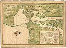
Before the 17th century, the region was populated by the Hackensack and Tappan, phratries of the Lenni-Lenape, an Algonquian people, who maintained semi-permanent and seasonal campsites[29] throughout the diverse landscape.
Director-General of New Netherland Peter Stuyvesant granted a charter in 1660 for a village at Bergen Square, considered the first autonomous municipality in New Jersey.
In 1664, four English frigates entered the Upper New York Bay, demanded, and peacefully received, control of Fort Amsterdam, and by extension, all of New Netherland.
Urbanization of the area began in the early 19th century with City of Jersey and the development of Hoboken, Weehawken, and Edgewater as summer resorts.
While some districts were laid out in an urban grid, others developed more randomly following the construction of coach and ferry roads, or drives leading to larger estates or farms.
Upon entry to World War I the US government took the Hamburg-American Line piers in Hoboken under eminent domain, and which became the major point of embarkation for more than three million soldiers, known as "doughboys".
In 1916, an act of sabotage literally and figuratively shook the region when German agents set off bombs at the munitions depot in New York Bay at Black Tom.
Among the many companies who had a presence along the waterfront were Colgate-Palmolive, Standard Oil, Port Johnston Coal Docks, Central Railroad of New Jersey, Lipton Tea, Maxwell House, Bethlehem Steel, Hamburg-American Line, Ford Motor Company, Lever Brothers, and Archer-Daniels-Midland[37] The Military Ocean Terminal at Bayonne opened during World War II.
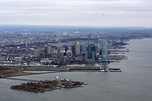
[41] Since the 1990s the Hudson Waterfront has experienced intensive development, consisting largely of high-density residential buildings, office towers, and retail centers.
Some of this development is on brownfields that were once factories, warehouses, docks, and rail yards, particularly in areas along public transportation corridors.
It has been called the Gold Coast,[42][43] a relatively new term coined by real estate agents, brokers, and developers in the 1980s, who realized the investment potential of the area.
[44] The Hudson River Waterfront Walkway has been constructed to provide contiguous public access to the water's edge with an 18.5-mile (29.8 km) pedestrian promenade.