Hume Highway
[11] Other than sections within the urban areas of Sydney and Melbourne, Hume Highway is generally dual-carriageway (with at-grade intersections and restricted entry from adjoining land), with considerable lengths which are of full freeway standard.
In addition to these bypasses the sections between Casula (in southwestern Sydney) and Berrima (built 1973–92), and Broadford to Wallan (1976), which were both constructed as major deviations, are also of full freeway standard.
[citation needed] The entire section in Victoria is categorised as a freeway by government roads authority VicRoads, although a few intersections along the route are not yet grade-separated.
At its Melbourne end, the original alignment of the Melbourne–Sydney route followed Royal Parade northward from where it begins at its intersection with Elizabeth Street and Flemington Road.
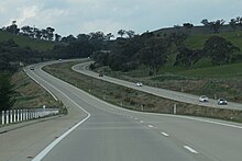
Mount Buffalo can be seen in the distance to the east as the highway comes down off the Warby Range near Glenrowan, and a museum commemorating Ned Kelly is located nearby.
To climb from the coast to the tablelands, Hume Highway uses the Bargo Ramp, a geological feature which provides one of the few easy crossings of the escarpment.
The climb from the western side of the Nepean River at Menangle up to Mittagong is fairly sustained, a fact that is hard to appreciate at high speed on the modern freeway.
[15] Mitchell's route in New South Wales, except for the current-day bypasses at Mittagong, Berrima and Marulan (dual carriageways were completed in 1986), is still largely followed by today's highway.
Mitchell's original route between Albury and Melbourne went through Mitchellstown on the Goulburn River and took a long detour to the west of Mount Macedon.
In 2008, VicRoads undertook a planning study for the upgrading of Hume Freeway by removal of direct access from adjoining properties and grade-separation of the intersections between Kalkallo and Beveridge.
[40] The study, completed in March 2009, ensured council planning schemes were amended so as to reserve space for the upgrade, but no timetable had been set for the project.
In April 2007, 'point-to-point' fixed speed-camera sites were installed, in the median strip along the Craigieburn Bypass section and northward to Broadford, in Victoria, at roughly 15–20 km intervals.
Ashfield – Chullora: Chullora – Warwick Farm: Warwick Farm – Casula: Casula – Prestons: Prestons – Campbelltown: Campbelltown – Ettamogah: Ettamogah – NSW/VIC border: NSW/VIC border – Campbellfield: Hume Highway exits and major intersections are spread across 840 kilometres (520 mi)[1][2][3][4] in the Australian states of New South Wales and Victoria.
In Sydney, Hume Highway stretches 31 kilometres (19 mi) southwest from Ashfield in the inner west to Prestons via Enfield, Greenacre, Villawood, Liverpool and Casula.
[1] From Sydney's southwestern outskirts; Hume Motorway stretches 88 kilometres (55 mi) south by southwest, from Prestons to outside Berrima bypassing Campbelltown, Camden, Mittagong, Bowral and Moss Vale.
[2] From outside Berrima, Hume Highway stretches 426 kilometres (265 mi) southwest by west, bypassing Sutton Forest, Marulan, Goulburn, Yass, Bowning, Bookham, Jugiong, Gundagai, Holbrook, Thurgoona, Lavington and Albury before crossing the Murray River and entering Victoria.
[3] From this point Hume Freeway continues 295 kilometres (183 mi) southwest by south, bypassing Wodonga, Chiltern, Wangaratta, Benalla, Seymour, Broadford, Beveridge, Craigieburn and terminating at Thomastown.
From Sydney, southwards to the Victorian border, the bypassed towns include Campbelltown, Camden, Picton, Mittagong, Berrima, Marulan, Goulburn, Gunning, Yass, Bowning, Bookham, Jugiong, Coolac, Gundagai, Tarcutta, Holbrook, Woomargama, Albury and Young.
They are, in order from the NSW border, Wodonga, Chiltern, Wangaratta, Benalla, Violet Town, Euroa, Seymour, Broadford and Craigieburn.
Aboriginal stone tools have also been found on the banks of Towrang Creek, indicating that this was a route well-travelled long before Hamilton Hume came this way in 1824.
There is also a rest area on the eastern side of the highway, where a well-preserved bridge dating from 1839 (possibly designed by David Lennox) and a 1960s concrete box culvert can be viewed.
A number of architecturally and historically significant buildings are located near Belmore Park, including the courthouse, the post office and the railway station.
For many years Bookham became a quiet hamlet of two historic churches, a cricket ground, a successful worm farm and two thriving old and new machinery yards.
The main features of this section of the highway were a deep, narrow cutting and the reinforced concrete bowstring arch bridge over Hillas Creek.
Holbrook had the only set of traffic signals (for pedestrians) that remained on the Hume Highway between the Sydney Orbital and Melbourne's Western Ring Road.
The route is visible on aerial imagery (when water levels are low), following a line from the intersection with Table Top Road, pointing directly to Bowna and Mullengandra.
Albury's history is linked with the two famous Australian explorers, Hamilton Hume and William Hovell, as the city's location sprung from their crossing of the Murray River.
Albury, commonly associated with its Victorian twin, Wodonga, is one of the few rural Australian cities to experience a boom, mainly from industrialisation in recent times.
Attractions include Merriwa Park, a sunken garden adjacent to the King River, Airworld at Wangaratta Airport, and old goldfield areas of nearby Beechworth and Chiltern.
Construction of the Donnybrook Road interchange, immediately to the north of the Craigieburn Bypass, replaced the dangerous[88] at-grade intersection with (C723) at Kalkallo an overpass and entry/exit ramps in both directions, at a cost of $32 million.