Hurricane Chantal (1989)
The third named storm and the first hurricane of the season, Chantal slowly developed on July 30 in the southern Gulf of Mexico from a tropical disturbance that was previously within Intertropical Convergence Zone (ITCZ) while near Trinidad and Tobago.
While making landfall in Texas, the storm produced relatively small tides, with most locations reporting waves less than 4 feet (1.2 m) in height.
Two tornadoes were reported, with one causing the destruction of a shed in Crystal Beach, Texas, and the other knocking over several trees and mobile homes in Iota, Louisiana.
The origins of Hurricane Chantal can be tracked back to a tropical disturbance within the Intertropical Convergence Zone near Trinidad and Tobago on July 24.
Although the outflow of the system had appeared impressive on satellite images, the potential for development seemed uncertain, mostly due to the close proximity to land.
[1][2] The following morning after development occurred, the depression had intensified into a tropical storm 575 miles (925 km) southeast of Texas; the National Hurricane Center assigned it to the name Chantal.
Tropical Storm Chantal rapidly strengthened thereafter, with weather satellites indicating t–numbers increasing from 2.5 to 3.5 within twelve hours using the Dvorak technique.
[3] Later on July 31, satellite imagery revealed better organization, and another reconnaissance flight found winds at 91 mph (146 km/h) while flying at 1,500 feet (460 m).
Hurricane Chantal continued to intensify, slightly, and attained its peak intensity on August 1 at 1000 UTC, reaching maximum sustained winds of 80 mph (130 km/h) and a minimum barometric pressure of 986 mbar (29.1 inHg).
[7] Mayor of Port Arthur Malcolm Grant asked 800 residents to evacuate Sabine Pass, due to potential coastal flooding isolating the area.
[6] Texas bore the brunt of the storm, where strong winds and heavy rainfall damaged about 3,000 homes and knocked downed numerous trees and signs.
The precipitation put out fires burning in the region, which had destroyed up to 370,000 acres (150,000 ha) of jungle in the two months prior to the tropical disturbance, according to the Agriculture Department of Mexico.
As a result, the highway was expected to be closed for at least five weeks,[9] though in October 1989, storm surge from Hurricane Jerry caused more erosion, and no repairs have been made since.
Rated as an F0 on the Fujita scale, the tornado was spawned in Crystal Beach, where it destroyed a boat shed; elsewhere, no damage occurred from this twister.
Significant amounts of precipitation resulted in flooding, which in turn, caused several hundred emergency crew rescues and damage to at least 500 homes.
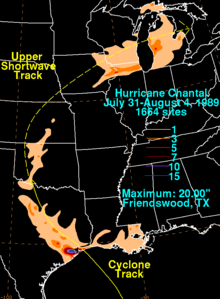
[9] Heavy rainfall affected Brazoria County, where precipitation amounts up to 12 inches (300 mm) were reported; this caused significant flooding, especially in Pearland and Manvel.
[9] Precipitation in Collin County reached as high as 16 inches (410 mm) in Clear Lake, though no flood damage was reported.
[4] Additionally, two fatalities occurred when two teenage boys were riding a rubber raft, swept into a drainpipe, and subsequently drowned.
Chantal and its remnants dropped mostly light rainfall in the states of Oklahoma, Missouri, Kansas, Iowa, Wisconsin, Illinois, Indiana, and Michigan.
[13] In Illinois, rainfall in Chicago flooded numerous streets and basements; Lake Shore Drive and Edens Expressway were briefly closed, as a result.
[7][9] In Vermont, the remnants of Chantal dropped rainfall in excess of 6 inches (150 mm) along the Caledonia, Orange, and Washington county lines.

Tropical storm (39–73 mph, 63–118 km/h)
Category 1 (74–95 mph, 119–153 km/h)
Category 2 (96–110 mph, 154–177 km/h)
Category 3 (111–129 mph, 178–208 km/h)
Category 4 (130–156 mph, 209–251 km/h)
Category 5 (≥157 mph, ≥252 km/h)
Unknown