Hurricane hunters
The civilian and NOAA Corps crew members of the NOAA Hurricane Hunters, originally based at the Aircraft Operations Center at MacDill AFB, in Tampa, Florida, mainly perform surveillance, research, and reconnaissance with highly instrumented aircraft including airborne Doppler weather radar measurements in both Atlantic and Pacific storms.
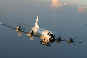
They fly two Lockheed WP-3D Orion aircraft, heavily instrumented flying laboratories modified to take atmospheric and radar measurements within tropical cyclones and winter storms, and a G-IV Gulfstream high-altitude jet above 41,000 feet (12 km) to document upper- and lower-level winds that affect cyclone movement.
The computer models that forecast hurricane tracks and intensity mainly use G-IV dropsonde data collected day and night in storms affecting the United States.
In 2011, the cooperation between GFS and the Observatory extended to reconnaissance flights to capture weather data for tropical cyclones over the South China Sea.
[5] In September 2016 they introduced the dropsonde system, which collects extra meteorological data on tropical cyclones to enhance the monitoring of typhoons.
The idea of aircraft reconnaissance of hurricane storm trackers was put forth by Captain W. L. Farnsworth of the Galveston Commercial Association in the early 1930s.
As a result, ships began to avoid the Florida Straits, depriving the Weather Bureau of valuable information.
On September 2, a pilot flying over the Florida Keys noticed a large cloud mass to the east and more north than it should have been.
The Cuban weather service requested a plane to be sent up to find the storm, with Captain Leonard Povey volunteering.
The landfall of Hurricane Katrina on 29 August 2005 devastated Keesler Air Force Base, home of the 53rd WRS.
A reality television series featuring the USAFR 53rd WRS, entitled Hurricane Hunters, debuted on The Weather Channel in July 2012.