Hydrography
Hydrography is the branch of applied sciences which deals with the measurement and description of the physical features of oceans, seas, coastal areas, lakes and rivers, as well as with the prediction of their change over time, for the primary purpose of safety of navigation and in support of all other marine activities, including economic development, security and defense, scientific research, and environmental protection.
National organizations, particularly navies, realized that the collection, systematization and distribution of this knowledge gave it great organizational and military advantages.
In practice this meant that ships often sailed with inadequate information for safe navigation, and that when new areas were surveyed, the data rarely reached all those who needed it.
In 1829, Rear-Admiral Sir Francis Beaufort, as Hydrographer, developed the eponymous Scale, and introduced the first official tide tables in 1833 and the first "Notices to Mariners" in 1834.
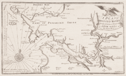
Large-scale hydrography is usually undertaken by national or international organizations which sponsor data collection through precise surveys and publish charts and descriptive material for navigational purposes.
The color filled areas that show different ranges of shallow water are not the equivalent of contours on a topographic map since they are often drawn seaward of the actual shallowest depth portrayed.
Another concept that affects safe navigation is the sparsity of detailed depth data from high resolution sonar systems.
This collection method drops a weighted line to the bottom at intervals and records the depth, often from a rowboat or sail boat.
Basin or interior hydrography pays special attention to rivers and potable water although if collected data is not for ship navigational uses, and is intended for scientific usage, it is more commonly called hydrometry or hydrology.
The United Kingdom Hydrographic Office is one of the oldest, supplying a wide range of charts covering the globe to other countries, allied military organizations and the public.
In the United States, the hydrographic charting function has been carried out since 1807 by the Office of Coast Survey of the National Oceanic and Atmospheric Administration within the U.S. Department of Commerce and the U.S. Army Corps of Engineers.