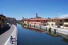
Hydrography of Milan
The hydrography of Milan and the area of the neighboring municipalities is particularly complex, both for natural causes, given the conspicuous presence of rivers, streams and fountains that form a real water tangle, and for issues related to the work of canalization and diversion of waterways made by man, having their beginning during the Roman era, which led to the creation of numerous irrigation ditches, canals and lakes.
The first description of the hydrography of Milan was made by Bonvesin de la Riva, an Italian writer and poet who lived between the thirteenth and fourteenth centuries.
Milan rests on a single type of soil of fluvio-glacial origin with carbonate cement, common to the whole Po Valley.
Of these, about 200 kilometers, concern the network of main or secondary waterways; the smaller ones measure a total of about 170 km, which are often fed directly or indirectly from the aquifer of Milan.
The first description of the hydrography of the Lombard city of Milan was made by Bonvesin de la Riva, an Italian writer and poet who lived between the thirteenth and fourteenth centuries.