Hydrology of Hungary
All surface water gravitates towards its southern center, and from there, is united in the Danube, which flows into the Black Sea.
Hydro graphically Hungary can be divided into two roughly equal parts: the drainage basins of the Danube and the Tisza.
The present network of Hungary's rivers began to take shape at the end of the Tertiary and the beginning of the Quaternary periods when the Pannonian Sea retreated from the basin.
The rivers in Hungary reach their lowest level at the end of the summer, the beginning of the autumn, or sometimes in the winter.
The "icy flood" is the result of the thaw in the mountains surrounding the Carpathian Basin, when the rivers in the plain are usually still frozen.
This phenomenon can still be a real danger after cold winters, and a small fleet of icebreakers is used on the two rivers to fight against ice barrages.
Later the Danube was diverted to the east by tectonic uplift, finding an outlet through the Visegrád gap.
During the Quaternary the Great Plain continued to sink, meanwhile the Börzsöny and the Visegrád mountains were rising.
Once through the gorge, the Danube fanned out into the Great Hungarian Plain, depositing alluvial cones.
Its upper flow is outside of Hungary, but its middle section starts at Devín, close to the Hungarian border.
The lower section of the river crosses the Romanian Plain and flows into the Black Sea through a delta.
The only right-hand tributary of any considerable volume is the Drava, which forms also on a large stretch the Hungarian-Croatian border, but joins the Danube already inside Croatia.
The Tisza and its tributaries built up very large, but flat alluvial cones along the edges of the Great Plain.
The rate of flow varies at Szolnok between 72 m3/s (2,500 cu ft/s) and 3,800 m3/s (130,000 cu ft/s) Before the extensive controls, when the spring floods of the Danube and the Tisza happened to coincide, the Danube could not absorb the water of the Tisza and the resulting flood could cause immense damage throughout the Great Plain.
Their confluence has often changed, as is graphically illustrated by the extensive oxbow lakes and belts of shallows in the vicinity of Tokaj.
Before the great river controls of the 19th century this region was an almost endless stretch of marshlands and fens.
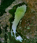
The most important canal of Transdanubia is the 100 km (62.1 mi) Sió connecting Lake Balaton and the Danube.
The 97 km (60 mi) long Main Eastern Canal, which was only finished after 1945, crosses the drier parts of the Great Hungarian Plain to the east of the Tisza.
There is a 70 km (43 mi) long beach ridge, covered by sand, on the southern shore, built up by the waves underneath the dominant north-westerly wind.
A prevailing north-easterly or south-westerly wind can push the water from the eastern basin of the lake (to the east of the Tihany Peninsula) into the western basin or on the contrary, resulting in water levels differing by 0.4 to 0.6 metres (1.3 to 2.0 ft) from normal, which creates strong currents.
The lake freezes almost every winter, the thickness of the ice can reach 0.4 metres (1.3 ft), which creates good opportunities for sport.
A quarter of the lake's area of 335 km2 (129 sq mi) lies in Hungary, with the other three-quarters in Austria.
They are fed mostly by warm springs, but karstic ones also occur (Lake Hévíz, the Malom Pool in Budapest, Tapolca).
They are predominantly of rainfall origin, mostly not from Hungary, but from the surrounding higher-lying parts of the Carpathian Basin.