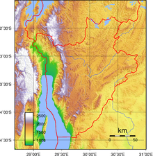
Natural regions of Burundi
It can be divided into four general topological zones: the Plain zone, holding the natural region of Imbo, with an altitude less than 1,000 metres (3,300 ft); the Congo-Nile ridge including the Mumirwa and Mugamba natural regions; the Central Plateaus including Kirimiro, Buyogoma, Bututsi, Bweru and Buyenzi; and the Depressions of Moso in the east, Buragane in the south, and Bugesera in the north.
[2] The original nine natural regions were based in part on geography, geology and climate, but also considered history, the economy and society.
[3] The current eleven regions are based on relief, climate, altitude and the nature of the soil.
They are Imbo, Mumirwa, Mugamba and Bututsi in the west; Buyenzi, Bweru, Kirimiro and Buyogoma in the center; Moso and Buragane in the east; and Bugesera in the north.
[4] A large part of the population of the Plain zone is urban, including residents of the capital Bujumbura and the cities of Rumonge and Nyanza Lac.
[3] The Imbo region (Région naturelle d'Imbo) extends along the East African Rift valley and the shore of Lake Tanganyika.
[4] The Imbo region is a narrow strip along the east of the Rusizi River and Lake Tanganyika.
[6] The Congo-Nile ridge is an immense steep slope with very rugged relief that forms the divide between the Nile and the Congo River.
[1] The Central Plateaus contain the natural regions of Kirimiro, Buyogoma, Bututsi, Bweru and Buyenzi, and is mostly 1,500 to 1,800 metres (4,900 to 5,900 ft) above sea level.
[1] The term "central plateaus" is somewhat misleading, since there is varied topography including very steep slopes.
[4] In Buyogoma, lithosols develop on ferruginous crusts on the tops of the hills, often with very hard lateritic beds.
[9] The Depressions hold the natural regions of Moso in the east, Buragane in the south and Bugesera in the north.
To the west it is bounded by the slopes of the eastern part of the central plateaus, to the northeast by Tanzania and to the south by the southern termination of the Congo-Nile ridge.
[14] Bugasera (Région naturelle du Bugesera) is a vast batholith, a depression of granite rocks.
[11] The Bugesera region is part of the Kirundo district, a depression in the inter-lacustrine zone of East Africa that extends across northeastern Burundi and southeastern Rwanda.