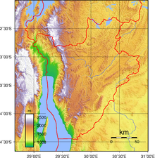
Mumirwa natural region
The Congo-Nile ridge is an immense steep slope with very rugged relief that forms the divide between the Nile and the Congo River.
Mumirwa natural region covers the western foothills, or "Mirwa", of the ridge, while the Mugamba natural region contains the highest part of the ridge.
[3] The Mumirwa region is part of the western slope of the Congo–Nile Divide, above the plains along the Rusizi River and Lake Tanganyika, and below the high peaks of the divide, with altitudes of 1,000 to 1,900 metres (3,300 to 6,200 ft).
[4] All the rivers flowing from the mountains of Burundi into the Congo Basin run through the region.
Annual rainfall is 1,100 to 1,900 millimetres (43 to 75 in), with a dry season lasting about three months.