Imperial Route of the Community of Madrid
The Imperial Route of the Community of Madrid is the tourist itinerary promoted by the Ministry of Culture and Tourism of this Spanish region, which runs through several municipalities in the Sierra de Guadarrama.
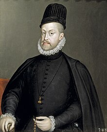
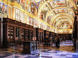
It partially follows the historical road that led to the Monastery of El Escorial, used in the 16th century by King Philip II in his travels from the city of Madrid to the Royal Site.
Among them are Torrelodones, Collado Villalba (through the place known as La Venta) and Guadarrama, which, from the 16th century, saw an important hotel business flourish, aimed at travelers seeking rest on their journeys to San Lorenzo de El Escorial.
Their presence in the Imperial Route aims to promote the development of a tourist industry, taking advantage of the fame achieved by the Royal Site.
Various engineering works, such as the construction of bridges and the improvement of the roadway, carried out shortly before the completion of the monastery, were sufficient for the monarch to opt for this new route.
Galapagar's connection with the Royal Foundation can be seen in the church of Nuestra Señora de la Asunción, which has touches of the Escorial style in the spire that crowns its tower.
The ruins of the Casa Veleta, built by the king as a resting place, offer another example of the importance achieved by this municipality during the works of the Monastery.
One of the most characteristic features of the Herrerian style, the slate pyramidal spire with a pointed top, is present in the towers of the main churches of different localities in Guadarrama.
Within the route, the Herrerian churches found here present a sober and imposing appearance, completely disproportionate to the size of the small towns where they are located, as is the case with the monastery of El Escorial itself.
[4] The church of Nuestra Señora de la Estrella, in Navalagamella, declared an Asset of Cultural Interest by the Community of Madrid, also stands out for its proportions.
In this village we also find the Fountain of El Caño (16th century), a work of monumental nature that the neighbors financed to make the Court's stay more pleasant.
This architect was also responsible for the urban reorganization of the hamlet that arose behind the Lonja and, in its network of squares and streets, he maintained the Herrerian imprint.
The area, which suffered a strong degree of depopulation during the Early Middle Ages, practically lacks relevant monuments prior to the 15th century, when the Gothic, in its later version, penetrated the Madrid side of the Sierra de Guadarrama.
Among the pre-medieval constructions, the Seat of Philip II, in San Lorenzo de El Escorial, stands out, perhaps the oldest human footprint of the Imperial Route.
The abandoned village of Navalquejigo, in the municipality of El Escorial, houses a small church dating from the late 12th or early 13th century, which is in a ruinous state.
The church, which has a fortified appearance, houses a segmented baptismal font, a carving attributed to Alonso Berruguete and an altarpiece by Antonio Rincón, painter to the chamber of the Catholic Monarchs.
[11] In the parish churches after the 15th century, there are slight Renaissance touches combined with regional elements, characteristic of the rural architecture of Guadarrama.
This is the case with the church of San Bartolomé, in Fresnedillas de la Oliva, from the 16th century, which has a single nave and a choir supported by 17th-century columns, and also of the church of El Enebral (17th century), of Collado Villalba, decorated externally with stone balls, a very frequent ornamental resource in the constructions of the mountain chain.
Of note are the church of San Miguel Arcángel, the Fuente de Piedra, begun in 1785 in Baroque style, and the Puente del Rosario, built in the time of Charles III over the Guadarrama River.
[13] The Imperial Route includes the Valley of the Fallen, in the vicinity of San Lorenzo de El Escorial, the most important 20th-century construction on the itinerary.
The base of the cross is guarded by four large sculptures (approximately 18 m; 59 ft), representing the evangelists, the work of Juan de Avalos.
It partially crosses two Regional Parks, a Natural Monument and a Paraje Pintoresco, as well as other areas, not legally protected, of great scenic and environmental value.
In its first section (Torrelodones-Collado Villalba-Guadarrama), it runs through one of the western ends of the Cuenca Alta del Manzanares Regional Park, which partially includes the first two municipalities.
In addition, part of Torrelodones is within the Regional Park of the middle course of the Guadarrama River and its surroundings, although it is far from the A-6 (Madrid-A Coruña highway), along which the Imperial Route runs in its first section.
La Herrería, on the other hand, has a great historical importance, since, in the 16th century, it was part of the so-called Fence of Philip II, which delimited different estates used for the leisure and recreation of the monarch.
Further south, in Valdemorillo, the Aulencia —a tributary of the Guadarrama— forms the most important wetland of the Imperial Route and one of the most significant in the region, the Valmayor reservoir.