Interstate 59 in Alabama
Continuing on through rural forest land, I-20/I-59 crosses the Toomsuba Creek with an interchange shortly after for SR 17 for York at milepost 8.
The Interstate travels still in a northeast direction for another 9 miles (14 km) before crossing the Sucarnoochee River and meeting SR 28 for Livingston.
Still within forested terrain, the Interstate meets with SR 300 and stays in a northeast direction while skirting by more marshes before bridging the Black Warrior River.
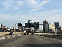
Turning back northeast and then entirely east, I-20/I-59 enters the developments of Birmingham and passes some of the city's neighborhoods such as Ensley, Belview Heights, and Central Park.
After exiting downtown but still heading through urbanized development, I-20/I-59 intersects SR 79 (Tallapoosa Street) and then the highway turns southeast again for an interchange for the Birmingham–Shuttlesworth International Airport.
The Interstate has an indirect connection with SR 75 as it gently ascends a steep incline and enters the Cahaba River watershed whilst passing over US 11 (Gadsden Highway) without directly intersecting it.
Next, I-59 turns back to the northeast and meets the northern terminus of I-459 near Trussville as it leaves the developments of Birmingham and enters forested land again.
It continues through the forest for 4 miles (6.4 km) and reaches the main exit for Trussville while bypassing Grayson Valley and Chalkville to the southeast.
Turning back east again, I-59 bridges the Cahaba River and quickly slants northeast as it has another interchange with indirect access to US 11 and then enters St. Clair County.
As the Interstate skirts the foothills of the Appalachian Mountains, I-59 briefly parallels SR 211 for approximately 5 miles (8.0 km) before intersecting it at milepost 188.
The Interstate stays in a northeast direction, then makes a gentle curve to the northwest again where it continues to travel below the foothills of the mountains and crosses over US 11 indirectly for the second time.
The Interstate makes a turn back to the northeast and parallels the Big Wills Creek for 8 miles (13 km).
I-59 then approaches the commercial developments of Fort Payne as it reaches its next interchange with SR 35 for the downtown area and Pine Ridge.
[16][17] When I-59 was first established in the 1957 numbering plan designated by the American Association of State Highway and Transportation Officials, its proposed route was roughly the same as it travels today, as it would run from Chattanooga, Tennessee, to Meridian, Mississippi.
As a result, the planned routing of I-59 would run parallel to US 11, and the four-laned section of US 11 in Bessemer would be converted into an interstate-standard freeway, later I-59.
The first project involved 10.1 miles (16.3 km) of base and concrete pavement from US 11 near downtown Fort Payne to Rodgers as part of the Birmingham-Chattanooga link.
The other project, also in DeKalb County, had a length of approximately 6.546 miles (10.535 km) of base and concrete pavement from Rodgers Road to the Georgia state line, with the contractor here being Claussen-Lawrence Construction Co. from Augusta.
In Tuscaloosa County, I-59 required grading and drainage from Boyd Crossing to Union Church, a distance of 4.9 miles (7.9 km) and part of the Birmingham-Meridian link.
According to a report released by governor John M. Patterson and highway director Sam Englehardt, construction along I-59 added up to 75% of DeKalb County's $10.4 million program since January 1959.
[25] By July 6, 1965, a "determined effort" to speed up construction of 2.9 miles (4.7 km) along I-59 in Ensley was scheduled to be put under contract, according to a State Highway Department official.
Assistant Division Engineer Randolph Rowe announced that the project, which was estimated to cost over $5 million, would be the largest contract along an Interstate let to date in Jefferson County.
[26] On August 19, 1966, the State Highway Department accepted bids on three Birmingham projects, one of which also included a multi-million dollar section of the Interstate in the western portion of the city.
[31] The opening of a section of I-59 in Tuscaloosa from US 82 (McFarland Boulevard) to SR 69 commenced on October 19, 1973, with a cost of $4.3 million by George Wallace.
The design problems led to a large number of lane changing errors and vehicle accidents, massive congestion, and long delays.
[37] As it aged, the interchange started showing signs of deterioration and required repeated repairs to bridge rails and decks.
Originally, ALDOT proposed several options in order to remedy traffic, such as placing I-20/I-59 on a separate 2.5-mile (4.0 km) corridor to intersect I-65 at a different interchange, but that solution would have required construction of a 16-lane Interstate through Birmingham neighborhoods.
Although only the tanker truck driver was killed, 140,000 vehicles were cut off from access to the interchange and ALDOT was forced to close the bridge for 37 days to make repairs.
With federal aid, warning lights that flash when vehicles drive through ramps going too fast were to be installed in approximately two or four months.
[40] In 2018, I-20/I-59 was closed for 14 months in order to completely reconstruct the interchange with new vertical columns replacing the old elevated portions that traveled through the city's main district.
[41] A project designed to reconstruct and expand a 4-mile (6.4 km) segment of I-59 from the I-459 interchange in northern Birmingham to Chalkville Mountain Road in Trussville was announced in 2022.