Interstate 70 in Utah
The freeway was built as part of a system of highways connecting Los Angeles and the Northeastern United States.
For example, the 110 miles (180 km) stretch between Green River and Salina makes up the longest distance anywhere in the Interstate Highway System with no motorist services.
It has also been a motivating factor for environmentalists to create a new national park along the path of the highway to protect scenic areas around the route.
[4] The descent into Clear Creek features a brake check area and runaway truck ramp to aid truckers down the steep slope.
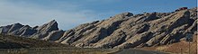
[9] The route to Green River crosses two major geographic obstacles: the Wasatch Plateau and the San Rafael Swell.
[13] The swell is noted for its sheer canyons and rock formations and is home to a large amount of exposed dinosaur remains.
[14] The highway ascends the western edge of the swell on a steady slope loosely following the north rim of Devils Canyon.
[1] About halfway down is a view area of the canyon narrowing as it approaches the eastern escarpment of the swell, the San Rafael Reef.
Just as the highway exits the swell near Green River, it passes to the north of Goblin Valley State Park.
Also at Green River, the freeway reaches the southern edge of the Book Cliffs, a mountain range which I-70 follows to Grand Junction, Colorado.
Other listed attractions along the byway near this section include Canyonlands National Park and various areas with Morrison Formation, a layer of rock where dinosaur remains are common.
[21] The first attempt to build a modern trade route through the area is credited to William Jackson Palmer, founder of the Denver and Rio Grande Western Railroad (D&RG).
It was soon obvious that the southern route was unfeasible given the remote area, technology available at the time, and the rough terrain of the San Rafael Swell.
One of the accounts in the book Utah Ghost Rails states the railroad fired the lead surveyor, even though the workers had graded a path past the San Rafael Reef.
According to a sign placed by the Bureau of Land Management (BLM), had the southern route succeeded, it would have been the shortest transcontinental railroad in the US.
[24] Construction resumed in 1901 on a portion of the southern route, to build a spur line to service coal mines on the Wasatch Plateau.
[24] By the time the Interstate Highway System was in the planning stages, no paved road had yet entered the San Rafael Swell.
The planners opposed the extension to Salt Lake but felt the modified proposal would benefit the US Army by providing a better connection to southern California.
[2][9] Utah officials attempted to revert plans to their preferred alternative but later resigned to construct I-70 on the federally selected route.
Governor George Dewey Clyde concluded, "Utah had no choice but to accept the Cove Fort routing, or have none at all.
[2] I-70 was dedicated on December 5, 1970, at the Ghost Rocks view area inside the swell, even though it would take another 20 years to fully complete the freeway.
Then-Governor Cal Rampton noted that I-70 was the longest road the US had built over a completely new route since the Alaska Highway, during World War II.
The official highway map for Utah noted the new freeway but qualified its existence with the words "two lanes open".
[3] The Utah portion of I-70 was not completed to Interstate Highway standards until October 1990, when the second Eagle Canyon bridge was dedicated.
Archie Hamilton, one of three engineers who worked for UDOT long enough to see I-70 progress from conception to completion, said the most memorable moment was seeing the excavation at Spotted Wolf Canyon.
Previously, these were isolated farming communities, whose residents felt they were unaccustomed to the crime and other effects that a transcontinental highway can bring.
Panic ensued after the public witnessed Utah Highway Patrol troopers carrying away a suspect in handcuffs while removing plastic bags and coolers full of body parts from the trunk of his car.
A major push occurred in 2002 when officials from Emery County, joined by Utah governor Mike Leavitt, petitioned President George W. Bush to use the authority of the Antiquities Act and create a San Rafael Swell National Monument.
[36] This effort lost momentum after the governor promised to honor the wishes of Emery County residents via a nonbinding referendum, which did not pass.
[37] Common reasons given by residents for opposing the designation included fear of the federal government restricting access and a repetition of events that occurred with the Grand Staircase–Escalante National Monument.