U.S. Route 191 in Utah
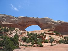
US Route 191 enters Utah on Navajo Nation land and crosses mostly desolate parts of the state.
Between Vernal and the Wyoming State line, vehicles longer than 95 feet (29 m) are required to have two certified pilot escorts.
[2] The independent portions of US 191 south of Interstate 70, as well as the concurrencies with I-70, US-6, and US-40, are included as part of the National Highway System.
[3] When US-191 was created in 1926, it did not enter Utah, only running from Idaho Falls northeast to Yellowstone National Park.
After overlapping US-6 past Green River, the routing followed and replaced a large portion of US-163 to a junction southwest of Bluff.
Between Bluff and Mexican Water, Arizona, US-191 followed a newly constructed road across the Navajo Nation, and then replaced State Route 63, still mostly inside the reservation, to I-40 at Chambers.
The road from Bluff north via Monticello, Moab, and Valley City to Thompson (a station on the Denver and Rio Grande Railroad) became a state highway in 1910.
First, in the late 1930s, U.S. Route 160 replaced US-450, continuing to enter the state east of Monticello and end at Crescent Junction.
[citation needed] The 1977 renumbering saw the elimination of SR-9 and SR-47, by then no longer signed due to the concurrent U.S. Highway designations.
The legislature did not specify where it would intersect the border,[28] and the State Road Commission initially routed it along former SR-220 to Linwood.
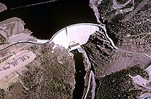
[29] However, the law was amended in 1963 to define the north end to be east of the reservoir,[30] and soon the lake began to fill, cutting off the road to Linwood (and inundating that settlement).