Republic of Ireland–United Kingdom border
As the two states share a Common Travel Area and (as of 2021[update]) Northern Ireland (the only exception within the UK and only in some respects) and the Republic of Ireland are participants in the European Single Market,[needs update] the border is essentially an open one, allowing free passage of people since 1923 and of goods since 1993.
The Brexit withdrawal agreement commits all involved parties to maintaining an open border in Ireland, so that (in many respects) the de facto frontier is the Irish Sea between the two islands.
The border became an international frontier after the Parliament of Northern Ireland exercised its right to opt out of the Free State on 7 December 1922.
[6][9] The interim boundary was formalised in December 1925 by an inter-government agreement that was ratified by the three parliaments in London, Dublin and Belfast, without changes from the 1920 demarcation lines.
[11] These controls were maintained, with varying degrees of severity, until 1 January 1993, when systematic customs checks were abolished between European Community member states as part of the single market.
Except during a brief period during World War II, it has never been necessary for Irish or British citizens to produce a passport to cross the border.
[16] In a statement to Dáil Éireann, the Irish Taoiseach Bertie Ahern assured the House that "British authorities have no plans whatsoever to introduce any controls on the land border between North and South.
[18] In a joint statement, Jacqui Smith, the British Home Secretary, and Dermot Ahern, the Irish Justice Minister, said: It is crucial that our two countries work closely together to ensure our borders are stronger than ever.
[17] The Times reported that another consultation paper was to be published in the autumn of 2008 on whether people travelling between Northern Ireland and the rest of the United Kingdom should be subject to further checks.
One proposal is expected to suggest extending the electronic borders scheme, requiring travellers from Northern Ireland to provide their personal details in advance.
2011 marked the first public agreement between the UK and Irish governments concerning the maintenance of the Common Travel Area.
[21] The Troubles in Northern Ireland required that attempts were made from the early 1970s until the late 1990s to enforce border controls.
Many smaller cross-border roads were cratered or blockaded by the British Army with the intention of making them impassable to regular traffic.
However, greater European integration led to roughly similar tax rates on most items and easing of restrictions on cross-border trade.
[26] Following the Northern Ireland peace process, military electronic surveillance and permanent vehicle checkpoints have been replaced by routine PSNI patrols.
[30] This was opposed by the subsequent British government as producing an effective border between Great Britain and Northern Ireland.
In this regard, James Craig, the Prime Minister of Northern Ireland put the following question in the British House of Commons on 27 November 1922 (the month before the establishment of the Irish Free State):[41] Another important matter on which I should like a statement of the Government's intentions, is with regard to the territorial waters surrounding Ulster.
I understand there is considerable doubt in the minds of lawyers and others as to whether these Parliamentary counties carry with them the ordinary territorial waters, extending three miles out from the shore.
That has been exercising the minds of a good many people in Ulster, and I shall be glad if the Government in due course will inform the House what is their opinion on the subject and what steps they are taking to make it clear.
[43] In 1927, illegal fishing on Lough Foyle had become so grave that Northern Ireland Prime Minister James Craig entered into correspondence with his Free State counterpart, W. T. Cosgrave.
Craig indicated to Cosgrave that he proposed to introduce a bill giving the Royal Ulster Constabulary powers to stop and search vessels on Lough Foyle.
[51]A corresponding statement was made by Conor Lenihan, then an Irish Government Minister: there has never been any formal agreement between Ireland and the United Kingdom on the delimitation of a territorial water boundary between the two states.
In the context of the Good Friday Agreement, a decision was taken to co-operate on foreshore and other issues that arise in the management of the lough[52]It is estimated that there are 300 major and minor crossings along the 499-kilometre (310-mile) border.
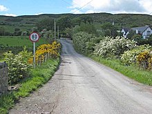
On larger roads, the approximate location of the border can be determined by signs reminding the driver of the change in units.
Road signs in both the Republic and those in Northern Ireland are mainly black/white/red triangles or circles (the same as the rest of the European Union).
Since the adoption by Ireland of metric speed limits, warning signs have been placed on either side of the border to alert motorists to the change to or from miles or kilometres per hour.
This was a source of annoyance to those resident in border areas when roaming charges were incurred with most service providers if the phone connects to the "wrong" network when making or even receiving a call.
In 2018, an anonymous Twitter account called @BorderIrish gained notability tweeting as the Irish border in the first person, and the implications that Brexit would have for it.
[59][60][61] The work of Irish folk-punk singer Jinx Lennon sometimes draws inspiration from his upbringing along the border as well as societal issues which affect the people living there.
[62] The following cities, towns and villages are located on the border or not far from it (listed from Lough Foyle to Carlingford Lough): The European Union Exit Analysis Branch identified fifteen principal points near border crossings in 2018, so they could be used as inspection points in case a post-Brexit deal collapsed.