Counties of Ireland
They began as Norman structures, and as the powers exercised by the Cambro-Norman barons and the Old English nobility waned over time, new offices of political control came to be established at a county level.
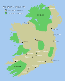
At that time Ireland was divided into a patchwork of petty kingdoms with a fluid political hierarchy which, in general, had three traditional grades of king.
A Irish: túath was an autonomous group of people of independent political jurisdiction under a rí túaithe, that is, a local petty king.
[6] The same process occurred after the Norman conquest of England where despite there being a strong central government, county palatines were needed in border areas with Wales and Scotland.
[8] The division of Leinster and Munster into smaller counties is commonly attributed to King John, mostly due to a lack of prior documentary evidence, which has been destroyed.
[10] These counties were: in Leinster: Carlow (also known as Catherlogh), Dublin, Kildare, Kilkenny, Louth (also known as Uriel), Meath, Wexford, Waterford; in Munster: Cork, Limerick, Kerry and Tipperary.
[13] The exact boundaries of the liberties and shrievalties appear to have been in constant flux throughout the Plantagenet period, seemingly in line with the extent of English control.
[14] For example, in 1297 it is recorded that Kildare had extended to include the lands that now comprise the modern-day counties of Offaly, Laois (Leix) and Wicklow (Arklow).
[16] Throughout the rest of Ireland, English rule was upheld by the earls of Desmond, Ormond, and Kildare (all created in the 14th-century), with the extension of the county system all but impossible.
[16] During the reign of Edward III (1327–77) all franchises, grants and liberties had been temporarily revoked with power passed to the king's sheriffs over the seneschals.
In 1333, the Earldom of Ulster is recorded as consisting of seven counties: Antrim, Blathewyc, Cragferus, Coulrath, del Art, Dun (also known as Ladcathel), and Twescard.
[20] Having declared himself King of Ireland in 1541, Henry VIII went about converting Irish chiefs into feudal subjects of the crown with land divided into districts, which were eventually amalgamated into the modern counties.
[20] Around 1545, the Byrnes and O'Tooles, both native septs who had constantly been a pain for the English administration of the Pale, petitioned the Lord Deputy of Ireland to turn their district into its own county, Wicklow.
[12] Sydney also sought to split Wexford into two smaller counties, the northern half of which was to be called Ferns, but the matter was dropped as it was considered impossible to properly administer.
[12][26] The Desmond rebellion (1579–83) that was taking place in Munster stopped Sydney's work and by the time it had been defeated Sir John Perrot was now Lord Deputy, being appointed in 1584.
[12] There were two other long recognised entities north of Louth—Antrim and Down—that had at one time been "counties" of the Earldom of Ulster and were regarded as apart from the unreformed parts of the province.
[12] Perrot was recalled in 1588 and the shiring of Ulster would for two decades basically exist on paper as the territory affected remained firmly outside of English control until the defeat of Hugh O'Neill, Earl of Tyrone in the Nine Years' War.
[27] After O'Neill and his allies fled Ireland in 1607 in the Flight of the Earls, their lands became escheated to the Crown and the county divisions designed by Perrot were used as the basis for the grants of the subsequent Plantation of Ulster effected by King James I, which officially started in 1609.
[12] Around 1600 near the end of Elizabeth's reign, Clare was made an entirely distinct presidency of its own under the Earls of Thomond and would not return to being part of Munster until after the Restoration in 1660.
Throughout the Elizabethan era and the reign of her successor James I, the exact boundaries of the provinces and the counties they consisted of remained uncertain.
Members of grand juries were the local payers of rates who historically held judicial functions, taking maintenance roles in regard to roads and bridges, and the collection of "county cess" taxes.
He controlled the boards of guardians and appointed the dispensary doctors, regulated the diet of paupers, inflicted fines and administered the law at petty sessions.
[29] The counties were initially used for judicial purposes, but began to take on some governmental functions in the 17th century, notably with grand juries.
In 1836, the use of counties as local government units was further developed, with grand-jury powers extended under the Grand Jury (Ireland) Act 1836.
Also in that year, local poor law boards, with a mix of magistrates and elected "guardians" took over the health and social welfare functions of the grand juries.
The 1898 Act changed the boundaries of Counties Galway, Clare, Mayo, Roscommon, Sligo, Waterford, Kilkenny, Meath and Louth, and others.
This partition was entrenched in the Anglo-Irish Treaty, which was ratified in 1922, by which the Irish Free State left the United Kingdom with Northern Ireland making the decision to not separate two days later.
[34] The possibility of a similar action with regard to Waterford City has been raised in recent years, though opposition from Kilkenny has been strong.
Under the Electoral Act 1997, as amended, a Constituency Commission is established following the publication of preliminary census figures every five years.
Twenty-four counties still delimit the remit of local government areas in the Republic of Ireland (in some cases with slightly redrawn boundaries).