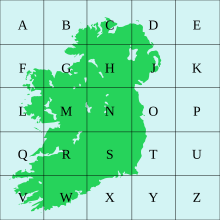
Irish grid reference system
In general, neither Ireland nor Great Britain uses latitude or longitude in describing internal geographic locations.
Additionally grid references are commonly quoted in other publications and data sources, such as guide books or government planning documents.
In both systems, the true origin is at 53° 30' N, 8° W[3] — a point in Lough Ree, close to the western (Co. Roscommon) shore, whose grid reference is N000500.
The ITM system was specified so as to provide precise alignment with modern high-precision global positioning receivers.
Coordinates may also be given relative to the origin of the entire 500 by 500 km (310 by 310 mi) grid (in the format easting, northing).