Isaack Gilsemans
Gilsemans is most noted for joining the explorer Abel Tasman on his expedition in 1642-43 during which Tasmania, New Zealand and several Pacific Islands became known to Europeans.
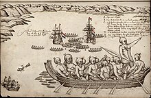
Gilsemans produced a number of drawings that documented island and native life.
[1][3] A sketcher and cartographer, he is thought to have been responsible for the coastal profiles in Tasman's journal and therefore the first European to make an image of Van Diemen's Land.
[4] Gilsemans' chart is responsible for documenting the first European landing in Tasmania in 1642,[5] as a result of which Gilsemans Bay near Dunalley is named after him.
You can help Wikipedia by expanding it.This article related to the history of Australia is a stub.