Abel Tasman
After leaving Batavia, Tasman sailed westward to Mauritius, then south to the Roaring Forties, then eastward, and reached the coast of Tasmania, which he named Van Diemen's Land after his patron.
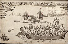
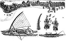
The encounter with the Māori people on the South Island of New Zealand resulted in a violent confrontation, which left four of Tasman's men dead.
Tasman continued to serve the Dutch East India Company until his death in 1659, leaving behind a legacy as one of the greatest explorers of his time.
The oldest available source mentioning him is dated 27 December 1631 when, as a seafarer living in Amsterdam, the 28-year-old became engaged to marry 21-year-old Jannetje Tjaers, of Palmstraat in the Jordaan district of the city.
[1][2][3] Employed by the Dutch East India Company (VOC), Tasman sailed from Texel (Netherlands) to Batavia, now Jakarta, in 1633 taking the southern Brouwer Route.
While based in Batavia, Tasman took part in a voyage to Seram Island (in what is now the Maluku Province in Indonesia) because the locals had sold spices to other European nationalities than the Dutch.
The fleet included the ships Engel and Gracht and reached Fort Zeelandia (Dutch Formosa) and Deshima (an artificial island off Nagasaki, Japan).
In August 1642, the Council of the Indies, consisting of Antonie van Diemen, Cornelis van der Lijn, Joan Maetsuycker, Justus Schouten, Salomon Sweers, Cornelis Witsen, and Pieter Boreel in Batavia dispatched Tasman and Franchoijs Jacobszoon Visscher on a voyage of exploration to little-charted areas east of the Cape of Good Hope, west of Staten Land (near the Cape Horn of South America) and south of the Solomon Islands.
[6] This was a purported yet non-existent landmass said to have plentiful gold, which had appeared on European maps since the 15th century, as a result of an error in some editions of Marco Polo's works.
On 7 November, snow and hail influenced the ship's council to alter course to a more north-easterly direction,[9] with the intention of having the Solomon Islands as their destination.
On 2 December, two ship's boats under the command of the Pilot, Major Visscher, rowed through the Marion Narrows into Blackman Bay, and then west to the outflow of Boomer Creek where they gathered some edible "greens".
(Tasman's original naming, Frederick Henrick Bay, was mistakenly transferred to its present location by Marion Dufresne in 1772).
When the land veered to the north-west at Eddystone Point,[13] he tried to follow the coast line but his ships were suddenly hit by the Roaring Forties howling through Bass Strait.
[18] He wrote, "it is possible that this land joins to the Staten Landt but it is uncertain",[19] referring to Isla de los Estados, a landmass of the same name at the southern tip of South America, encountered by the Dutch navigator Jacob Le Maire in 1616.
"[24] Tasman thought he had found the western side of the long-imagined Terra Australis that stretched across the Pacific to near the southern tip of South America.
When our two boats returned to the ships reporting that they had found not less than thirteen fathoms of water, and with the sinking of the sun (which sank behind the high land) they had been still about half a mile from the shore.
[8][28] Archaeologist Ian Barber suggests that local Māori were trying to secure a cultivation field under ritual protection (tapu) where they believed the Dutch were attempting to land.
Two names that the expedition gave to landmarks in the far north of New Zealand still endure: Cape Maria van Diemen and Three Kings Islands.
However, he missed the Torres Strait between New Guinea and Australia, probably due to the numerous reefs and islands obscuring potential routes, and continued his voyage by following the shore of the Gulf of Carpentaria westwards along the north Australian coast.
From the point of view of the Dutch East India Company, Tasman's explorations were a disappointment: he had neither found a promising area for trade nor a useful new shipping route.
In May 1648, he was in charge of an expedition sent to Manila to try to intercept and loot the Spanish silver ships coming from America, but he had no success and returned to Batavia in January 1649.
In November 1649, he was charged and found guilty of having in the previous year hanged one of his men without trial, was suspended from his office of commander, fined, and made to pay compensation to the relatives of the sailor.
[40] However, it is unclear if the drawing is of Tasman and its original source is unknown, although it has been said to resemble the work of Dutch engraver Jacobus Houbraken.
[42] In 1948, the National Library of Australia acquired from Rex Nan Kivell a portrait purporting to depict Tasman with his wife and stepdaughter, which was attributed to Jacob Gerritsz.
[47] Held within the collection of the State Library of New South Wales is the Tasman map,[48] thought to have been drawn by Isaac Gilsemans, or completed under the supervision of Franz Jacobszoon Visscher.
[52] The map includes the western and southern coasts of Australia, accidentally encountered by Dutch voyagers as they journeyed by way of the Cape of Good Hope to the VOC headquarters in Batavia.
However, the land areas adjacent to the Torres Strait are shown unexamined; this is despite Tasman having been given orders by VOC Council at Batavia to explore the possibility of a channel between New Guinea and the Australian continent.
[53] In 1943, a mosaic version of the map, composed of coloured brass and marble, was inlaid into the vestibule floor of the Mitchell Library in Sydney.