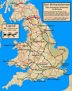
Antonine Itinerary
Seemingly based on official documents, possibly in part from a survey carried out under Augustus, it describes the roads of the Roman Empire.
Numerous manuscripts survive, the eight oldest dating to some point between the 7th to 10th centuries after the onset of the Carolingian Renaissance.
By then, its false data had infected almost every account of ancient British history, and had been adopted into the Ordnance Survey maps,[9] as General Roy and his successors believed it to be a legitimate source of information, on a par with the Antonine Itineraries.
While the document is no longer cited since its authenticity became indefensible, its data has not been systematically removed from past and present works.
[12] However, Arias may not have taken account of earlier work indicating that distances were measured between the edges of administrative areas of named settlements as opposed to centre-to-centre, thereby explaining supposed distance shortfalls and providing additional useful data on the approximate sizes of such areas.