Jacob Riis Park
It lies at the foot of the Marine Parkway–Gil Hodges Memorial Bridge, east of Fort Tilden, and west of Neponsit and Rockaway Beach.
[6]: 2 [8] In 1914, the park was renamed for Jacob Riis, a famous New York City muckraker journalist and photographer who documented the plight of the poor and working class.
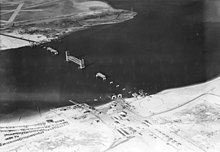
[4]: 5 (PDF p.11) [10]: 9 [12]: 2·3 [6]: 89 A streetcar line running across the peninsula, operated by the Ocean Electric Railway, opened in 1897, with its western end past Beach 149th Street within the modern park site.
[4]: 5 (PDF p.11) [10]: 9–10 In 1900, the property that would later would become Riis Park was acquired by Edward P. Hatch as part of two lots totaling 1,000 acres (404.685642240 ha) in size.
Much of the property north of Rockaway Beach Boulevard (then called Washington Avenue) would have been developed into recreational space with fields and courts for sports.
The Jamaica Bay coastline at the north end of the site would have been utilized for an additional beach and boardwalk, along with a marine basin for boats, and a lagoon.
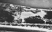
[10]: 40 On January 20, 1921, US Navy Rear Admiral James H. Glennon requested that the city cede the 94-acre (38 ha) site to the federal government in order to maintain the naval station.
[10]: 57 [37] On October 17, 1925, a ferry service was opened between Barren Island, Brooklyn (later Floyd Bennett Field airport) and Riis Park.
[46][10]: 61 Later that month, Benninger requested an additional $105,000 for the project from the New York City Board of Estimate, on top of the initial $425,000 appropriated.
[12]: 2·10 [46][10]: 70 Moses wished to develop Riis Park into an urban iteration of Jones Beach for working-class New York City residents.
[60] On August 6, 1934, Moses released his plan for Riis Park, designed by Gilmore D. Clarke, Julius Burgevin, W. Earle Andrews, and Clinton Loyd.
Among the reasons for the resistance were fears of bringing in individuals from other parts of the city to the Rockaways, and the possibility of Riis Park out-competing privately owned beaches and resorts, leading to declines in property values.
This plan moved the mall to the western end of the property, with a design similar to that of Orchard Beach which was being built in the Bronx at the same time.
[78][81][82] Others including New York City Comptroller Lawrence E. Gerosa desired for the property to be sold and developed, which would draw income from both the sale and taxes.
[98] Under NPS' purview, several renovations occurred, including the installation of new roofing on the bathhouse and mall buildings, and the restoration of the Wise Clock which had been taken out of operation.
[101] In spite of this, NPS rangers and officers maintained a policy of allowing nude bathers to remain so long as they "minded their own business.
[109] In the 1980s during summer months on weekends, the B9 and B46 bus routes were extended south of their normal terminus at Kings Plaza in Brooklyn to Riis Park, with a federal subsidy funding the extension.
[4]: 6 (PDF p.12) [114]: 34 [117] The plan was opposed by local residents and conservation groups, including the Sierra Club's New York branch and the National Audubon Society.
Among the points of contention were the idea of using federal parkland for amusement development, the additional noise and traffic created by the attractions, and the potential of disturbing the bird habitats in the area.
[118] On August 31, 1991, the beach was closed again due to the presence of medical waste, with over 500 items found including needles and medicine vials of the painkiller Nubain.
[122] By 2001, then-Senators Hillary Clinton and Chuck Schumer and then-Congressman Anthony Weiner had secured another $4 million in funds, most of which were targeted toward the renovation of the bathhouse.
[162] Riis as an LGBTQ gathering space has been mentioned in several works of literature including Audre Lorde’s Zami, Torrey Peters’ Detransition, Baby, and Sabrina Imbler’s How Far the Light Reaches.
[46] The bathhouse actually consists of four individual structures making up each face of the building, linked by common outer screen walls, with a central courtyard in between.
[46] The buildings share a common outer facade in terms of materials, consisting of brick laid in american bond, cast stone, and concrete.
Although built as a part of the 1932 bathhouse, the building underwent extensive renovations during the 1936-1937 projects, leading to its current Art Deco characteristics.
The bust rested on a granite pedestal constructed by the Parks Department with money from the Triborough Bridge and Tunnel Authority, the highway agency also controlled by Robert Moses.
[12]: 2·20 [10]: 166 [23] A replacement bronze bust was constructed by artist David Ostro, organized by students at the Immaculate Conception Catholic Academy in Jamaica Estates.
The TBTA operated the parking lot until 1968, when it in turn was merged with the Metropolitan Transportation Authority (MTA)'s Bridges and Tunnels division.
At the time it opened, it served the Neponsit, Roxbury and Breezy Point neighborhoods, as well as southern Brooklyn and Floyd Bennett Field.
[4]: 15 (PDF p.21) [12]: 5·4 [10][14] The crescent-shaped plot of land east of the parking lot, 30 acres (12 ha) in size, is undeveloped and consists of open grass and trees.