Japan Trench
Activity during the Cretaceous included subduction events as well as extensive accretion of sediment to the Northeastern Japan Arc that continues today.
[3] Volcanism decreased during the early Paleogene (66 ma), exposing the thickened Cretaceous-Paleogene 160 kilometres (99 mi) thick sediment sequence.
[5] During December 1994, transient crustal movements were recorded by a Global Positioning System (GPS) network after an inter-plate earthquake arose within the Japan Trench.
Ocean bottom seismometers placed in the base of the Japan Trench measures the ground for any motion created by recording the seismic waves emitted.
In 2012, the National Research Institute for Earth Science and Disaster Resilience (NIED) stationed in Tokyo started the construction of seismic and tsunami observation networks along the trench.
[13] Large magnitude and frequent earthquake activity occurring at the northern Japan Trench may be explained by variations in surface roughness of the subducting Pacific plate.
Regions of smooth ocean floor subduction are correlated with typically large under-thrust earthquakes within the deeper part of the plate interface zone.
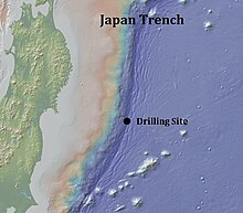
[14] In 1980, lipids samples were taken via sediment cores located on both the landward and distal sides of the Japan Trench during six sections of the Deep Sea Drilling Project's transect.
These studies and samples have supported the idea that these frictional properties of the fault zone possibly triggered the shallow and large slip during the Tohoku earthquake.
The small deep-sea basins with high sedimentation rates found along the Japan Trench pose favorable environmental conditions for the studying of turbidite paleoseismology.
16S ribosomal RNA genes were amplified through the use of polymerase chain reaction (PCR) to determine the nucleotides and identify the bacteria phylogenetically.