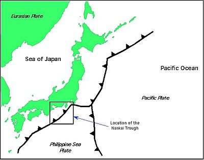
Nankai Trough
Within the Nankai Trough there is a large amount of deformed trench sediments (Ike, 2004), making one of Earth's best examples of accretionary prism.
Furthermore, seismic reflection studies have revealed the presence of basement highs that are interpreted as seamounts that are covered in sediments (Ike, 2004).
The detrital clays, primarily smectite, display variation over time and location in the Nankai Trough as well as the Shikoku basin.
At depth there is an increase in the smectite clay content in the sediments, inferring that there has been a change in the deposition source rock (Steurer et al., 2003).
Deformation is concentrated in the outermost imbricate zone, with a significant amount of "out of sequence" thrusting occurring landward.
Based on the work of Operto et al., 2006, several areas of intense tectonic activity in the Nankai Trough were identified using full waveform tomography.
IODP Expedition 370 will seek to find the temperature limit of the deepest life on Earth by drilling in the Nankai Trough, where heat flow is particularly high near its boundary with the subducting young, hot Philippine Sea tectonic plate.
[3] The Nankai Trough is the near-surface extension of a zone of active seismicity that dips beneath SW Japan.
These five subdivisions show interesting differences in earthquake behavior: frequency of earthquakes varying on a 90 to 150-year cycle (Mitsui, et al., 2004; Tanioka et al., 2004), similar slip occurrences along the fault segments, the order of subdivision faulting, and finally, different failure features.
Hydrologic observatories were placed in boreholes drilled in 2000 (IODP sites 808 and 1173) in an attempt to quantify changes in pore-fluid pressure that are a result of the oncoming Philippine Sea plate (Davis et al., 2006).
A seaward change in the pressure as measured by the borehole instruments likely indicates a relaxation of the sediments from the previous major thrust earthquake.
Using recent ocean bottom seismograph studies, it has been determined that most of the seismicity occurs near the trough axis (Obana et al., 2006).
Along the western area of the Nankai Trough, seismicity appears to be related to irregularities in crustal structure such as fractures generated from the subducted seafloor, including backarc basin crust of the Shikoku Basin, as well as due to serpentization of uppermost mantle beneath the overriding plate (Obana et al., 2006).
The source of water for the formation of gas hydrates frequently comes from the dewatering of a subducting slab as well as the overriding plate (Muramatsu et al., 2006).
The information concerning the gas hydrates in the Nankai Trough was initially published in 2000 by the Japan National Oil Corporations.