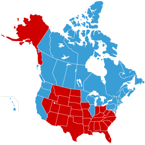
Jesusland map
[1] The map implies the existence of a fundamental political divide between contiguous northern and southern regions of North America, the former including both the socially liberal Canada and the West Coast, Northeastern, and Upper Midwestern states, and suggests that these states are closer in spirit to Canada than to the more conservative regions of their own country, which are characterized by the influence of Christian fundamentalism in their political and popular culture.
[citation needed] The Freakonomics blog opined that the map reflected the "despair, division, and bitterness" of the election campaign and results.
[2] Slate also covered the image and posited that it might be the reason the Canadian immigration website received six times its usual page views the day after the 2004 election.
[3] The original image was created on November 3, 2004, by G. Webb, a poster on yakyak.org, an Internet message board for fans of the work of Jeff Minter.
Some versions of the map include Alberta, Canada as part of "Jesusland" due to the province's predominantly conservative politics.