Johnston Atoll
[11] With elevation ranging from sea level to 5 m (16 ft) at Summit Peak, the islands contain some low-growing vegetation and palm trees on mostly flat terrain, and no natural freshwater resources.
[17] It is visited by migratory shorebirds, including the Pacific golden plover, wandering tattler, bristle-thighed curlew, ruddy turnstone and sanderling.
The ship's captain, Joseph Pierpont, published his experience in several American newspapers the following year, accurately portraying Johnston and Sand Island along with part of the reef.
The expedition to the atoll consisted of two teams accompanied by destroyer convoys, with the first departing Honolulu on July 7, 1923, aboard the USS Whippoorwill, which conducted the first survey of Johnston Island in the 20th century.
[33] However, the Department of Agriculture had no ships, and the United States Navy was interested in the atoll for strategic reasons, so with Executive Order 6935 on December 29, 1934, President Franklin D. Roosevelt placed the islands under the "control and jurisdiction of the Secretary of the Navy for administrative purposes", but subject to use as a refuge and breeding ground for native birds, under the United States Department of the Interior.
On February 14, 1941, President Franklin Roosevelt issued Executive Order 8682 to create naval defense areas in the central Pacific territories.
The proclamation established the "Johnston Island Naval Defensive Sea Area", encompassing the territorial waters between the extreme high-water marks and the three-mile marine boundaries surrounding the atoll.
Fish and Wildlife Service personnel, a Refuge Manager and a biologist, were stationed on Johnston Atoll to handle increased biological, contaminant, and resource conflict activities.
The outer islets and water rights were managed cooperatively by the Fish and Wildlife Service, with some of the actual Johnston Island land mass remaining under the control of the United States Air Force (USAF) for environmental remediation and the Defense Threat Reduction Agency (DTRA) for plutonium cleanup purposes.
[36] The Administration of President Barack Obama in 2014 extended the protected area to encompass the entire Exclusive Economic Zone, by banning all commercial fishing activities.
[1] During the Operation Hardtack nuclear test series from April 22 to August 19, 1958, the administration of Johnston Atoll was assigned to the Commander of Joint Task Force 7.
[citation needed] In 1935, personnel from the US Navy's Patrol Wing Two carried out some minor construction to develop the atoll for seaplane operation.
In November 1939, civilian contractors commenced further work on Sand Island to allow the operation of one squadron of patrol planes with tender support.
Sand Island had barracks built for 400 men, a mess hall, an underground hospital, a radio station, water tanks, and a 100 feet (30 m) steel control tower.
As a result, Air Micronesia's service was immediately discontinued, and missile firings were terminated, except for two 1975 satellite launches deemed critical to the island's mission.
In July 1942, the civilian contractors at the atoll were replaced by 500 men from the 5th and 10th Naval Construction Battalions, who expanded the fuel storage and water production at the base and built additional facilities.
[3]: 160 On January 25, 1957, the Department of Treasury was granted a 5-year permit for the United States Coast Guard (USCG) to operate and maintain a Long Range Aid to Navigation (LORAN) transmitting station on Johnston Atoll.
The "Fishbowl" series included four failures, all deliberately disrupted by range safety officers when the missiles' systems failed during launch and were aborted.
The subsequent nuclear weapon launch failures from Johnston Atoll caused severe contamination to the island and surrounding areas with weapons-grade plutonium and americium that remains an issue to this day.
The failure of the "Bluegill" launch created in effect a dirty bomb but did not release the nuclear warhead's plutonium debris onto Johnston Atoll as the missile fell into the ocean south of the island and was not recovered.
[27] Baker-Nunn were rendered obsolete with the Initial Operational Capability of 3 GEODSS optical tracking sites at Daegu, Korea; Mount Haleakala, Maui and White Sands Missile Range.
[51] The Air Force program was used as a cover for the initial development of the Central Intelligence Agency's Key Hole (including Corona and Gambit) reconnaissance satellites systems.
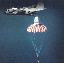
Men from the Johnston Atoll facility would recover the parachuting film canister capsules with a radar-equipped JC-130 aircraft by capturing them in the air with a specialized recovery apparatus.
[57] First isolated in 1964 the tick-borne virus was discovered in Ornithodoros capensis ticks, found in a nest of common noddy (Anous stolidus) at Sand Island, Johnston Atoll.
[59] According to Project SHAD veteran Jack Alderson, who commanded the Army tugs, area three at Johnston Atoll was located at the most downwind part of the island and consisted of a collapsible Nissen hut for weapons preparation and some communications.
After this date, the base was completely deserted, with the only structures left standing being the Joint Operations Center (JOC) building at the east end of the runway, chemical bunkers in the weapon storage area, and at least one Quonset hut.
The Air Force also initiated research on methods to remove dioxin contamination from soil resulting from leakage of the stored herbicide Agent Orange.
The stripped Johnston Island was briefly offered for sale with several deed restrictions in 2005 as a "residence or vacation getaway," with potential usage for "eco-tourism" by the GSA's Office of Real Property Utilization and Disposal.
The details of the offering were outlined on GSA's website and in a newsletter of the Center for Land Use Interpretation as unusual real estate listing # 6384, Johnston Island.
Twelve people were on the island when the hurricane struck, and part of a crew was sent to deliver a USAF contractor who sampled groundwater contamination levels.