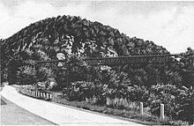
Joppenbergh Mountain
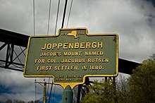
It was named after Rosendale's founder, Jacob Rutsen, and mined throughout the late 19th century for dolomite that was used in the manufacture of natural cement.
Extensive mining caused a large cave-in on December 19, 1899, that destroyed equipment and collapsed shafts within Joppenbergh.
Joppenbergh was put up for sale in 2009, and in March 2011, the Open Space Institute (OSI) offered to purchase the entire 117-acre (47 ha) property and sell it to the town.
The Rosendale town board initially agreed to the deal the following month, with payment planned to come from a surplus fund.
Rutsen was a merchant, and the son of a Dutch immigrant, from Albany; he founded the first settlement in what is now the town of Rosendale, New York, in the late 17th century.
[10] Both measurements give Joppenbergh a lower elevation than the highest point in the town of Rosendale, a 600-foot (180 m) peak of the Shawangunk Ridge.
[10] The bedrock underlying the mountain is composed of limestone and dolomite members of the Helderberg Group, laid during the Paleozoic era.
[11] The mountain's surface is composed of unconsolidated, glacially deposited outwash and till, with several outcrops exposing Joppenbergh's bedrock.
[13] In 1825, engineers working on the Delaware and Hudson Canal found extensive outcrops of dolomite in the region, which enabled the production of natural cement.
[28] That April, the Telemark club held a special dinner in Brooklyn to honor members who performed well in the January competition.
[30] Joppenbergh's ski track was coated with borax, and the tournament was held on July 18, 1937 at 2:30 in the afternoon, with enough parking provided for 500 cars.
[25] The JMC gained control of the property on August 20, 1964, and immediately announced its intent to build a new ski slope on the site of the original one, as well as a parking lot capable of holding 10,000 cars.
[50] In 1995 the mountain was studied by the New York Public Service Commission to determine a possible route for new transmission lines laid by a local energy utility.
[52] In 2003, the town of Rosendale considered either leasing a tract of land near Joppenbergh, or purchasing a 1+1⁄2-acre (0.61 ha) lot, to expand parking on Main Street.
[60] In early March 2011, the Open Space Institute (OSI) offered to purchase the 117-acre (47 ha) property – which had, by that time, been reassessed at $240,000[61] – for $185,000, and sell it to the town for $85,000.
The deal would create an easement with the town, allowing only noncommercial use of the mountain while preserving the municipal parking lot at its base.
During the hearing, members of the Rosendale town board determined that the tax income from the entire property was much less than the cost of renting part of it for parking.
[66] An individual living adjacent to the property, Brett Hansen, expressed a strong desire to buy it and build additional parking lots, as well as an amphitheater.
[67] Proponents of the purchase described how ownership of Joppenbergh would allow Rosendale to connect the Wallkill Valley Rail Trail with Main Street, and how property values near the mountain would increase.
[73] Owners of businesses on Main Street expressed concern at the June 1 town board meeting that the cost of parking would increase if the property was purchased by a third party.
[74] Ulster County Area Transit expressed a desire to route its buses through the property, creating a connection to the Mohonk Preserve.
[13] In an effort to reduce the purchase price, the town board asked the mountain's current owners to discount the final four years of rent on the parking lot, a cost of $32,000.
[71] Ultimately, the OSI bought Joppenbergh without any financial assistance from the town, gaining ownership of the property in October 2011,[77] although the sale was not completed until December 20, 2011.
[79] The town of Rosendale approached the OSI in January 2012 to renew its lease of the parking lot, which was set to expire at the end of 2013.
An informal association of businesses, the Joppenbergh Mountain Advisory Group (JMAG), began working with the WVLT to create a land use policy.
[82] In late September 2012, the WVLT held a hearing on a proposed land use plan that would allow deer hunting on the property beginning in 2013, and would prohibit entry into several caves on the mountain.