Jubilee River
[2] It was constructed in the late 1990s and early 2000s to take overflow from the River Thames and so alleviate flooding to areas in and around the towns of Maidenhead, Windsor, and Eton in the counties of Berkshire and Buckinghamshire.
[5] The scheme did not receive government approval until 1995; around the same time, there was further reorganisation of the water industry, with the Environment Agency replacing the National Rivers Authority.
The 19th-century Brunel-designed railway embankment continued in use, carrying passenger and goods trains between London and destinations including South Wales, Cornwall and Bristol throughout construction.
[2] The channel also had to be taken through Black Potts Viaduct, a series of 13 brick arches carrying the Waterloo to Windsor railway line over the Thames flood plain.
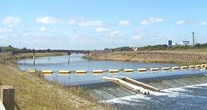
Protective concrete and blue brick barriers were built around the older brickwork to preserve the viaduct's structural integrity,[10] as well as to control gates to adjust the amount of water rejoining the Thames immediately downstream.
The 11.6 km (7.2 mi) channel involved complex civil engineering to deal with utility conduits, roads and railways, as well as ecological and social issues, entailing compulsory purchases, community lectures and consultations and a public enquiry.
This is normally controlled by measurements of the water levels below Boulters Lock and the estimated flow of the Thames at the Datchet gauging station near Windsor.
[2] The river is well used by walkers, runners, swimmers, canoeists, wildlife enthusiasts and cyclists: a footpath combined with National Cycle Route 61 runs along virtually its entire length.
A wide variety of bird life can be seen along the river, including green woodpeckers, cormorants, lapwing and red kites.