Kachin Hills
[2] According to the Kachin Hill Tribes Regulation of 1895, administrative responsibility was accepted by the British government on the left bank of the Irrawaddy for the country south of the Nmaikha, and on the right bank for the country south of a line drawn from the confluence of the Malikha and Nmaikha through the northern limit of the Laban district and including the jade mines.
South of that line peace was to be enforced and a small tribute taken, with a minimum of interference in their private affairs.
[2] On the British side of the border, the chief objects of Britain's colonial policy were the disarmament of the tribes and construction of frontier and internal roads.
– discuss] The continued "misconduct" of the Sana Kachins from beyond the administrative border rendered punitive measures necessary, in the eyes of British colonists.
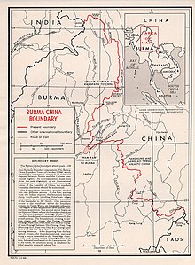
[5][6] Myanmar relinquished[3][7] the eastern villages of Hpimaw (Pianma) and adjacent Gawlam (Gulang)[8] and Kangfang (Gangfang)[9] to the People's Republic of China (PRC) in 1960, ending the political boundary dispute.