Kajaran
It is believed that the old spelling of the name was Kachachut (Armenian: Կաճաճուտ), mentioned by Stephen Orbelian in his 13th-century work History of Syunik Province.
In the late Middle Ages, the spelling was changed to Kchanants (Armenian: Քչանանց) which is still in use in the local accent of Syunik.
The old village of Kajarants -currently located 2 kilometers west of present-day town of Kajaran-, was part of the Dzork canton of the historic Syunik province of the ancient Kingdom of Armenia.
However, like most of the historic territories of Armenia, Syunik suffered from the Seljuk, Mongol, Aq Qoyunlu and Kara Koyunlu invasions, respectively, between the 12th and 15th centuries.
[3] The Persians ruled until the beginning of the 19th century, many territories of Armenia -including Syunik-, became part of the Russian Empire as a result of the Treaty of Gulistan signed on 24 October 1813, between Russia and Qajar Persia.
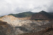
After the discovery of huge copper deposits in 1930, the Soviet government proposed to build a large copper-molybdenum plant.
In 1951, the Zangezur state-owned mining company was formed to organize the production process, becoming one of the largest enterprises of the Soviet Union at that time.
[4] In order to facilitate the copper and molybdenum production of the plant, the urban-type settlement of Kajaran was founded by the Soviet Armenian government in 1947, within the Kapan raion.
The majority of the population of Kajaran were Armenian workers resettled from the town of Kapan and the Nagorno-Karabakh Autonomous Oblast.
The Zangezur Copper and Molybdenum Combine continued its operations after the independence until 1994, when it was ceased due to the post-independence economic crisis.
The town is located on the border of two natural landscapes, alpine and highland forests at an average height of 1950 meters above sea level, on the banks of Voghji river, between the Zangezur Mountains and Meghri range.
Mount Kaputjugh which is the highest peak of Zangezour Mountains at 3905 meters, is located few kilometers west of Kajaran.
The relief is composed of placate rock strata of Araa river basin and is characterized by active erosion.
Kajaran is a part of Holarctis floristic province, Zangezur region, Voghji-Geghi area, characterised by prevalence of mesophytic, eurivalent and xerophytic plants.
Subalpine and alpine flora is represented by Gramieae, Poaceae Papilionacenae and Cyperaceae (feather-grass, brome-grass, cereals, sedge).
The habitats of the fauna in the area around the city include forests, sub-alpine and alpine zones with their characteristic flora.
The high level of female unemployment is due to the closure of weaving, relay and condenser manufacturing facilities, which used to employ the majority of women in the city.
Insufficient supply of housing in residential blocks forces the population to purchase apartments outside Kajaran, in the nearby communities.
The Bronze Age fort of Napat dating back to the 2nd millennium BC is found 4 km west of Kajaran.
The copper concentrate is transported to Alaverdi metallurgical plant and Armenian Molybdenum Production company in Yerevan for further processing.
Frequent awareness programs of ecology and environmental issues are presented by the municipality of Kajaran with the support of Zangezur Copper and Molybdenum plant.
The Zangezur Copper and Molybdenum plant who are the owners of FC Gandzasar representing the town of Kapan, are the sponsors of the sporting life in Kajaran.