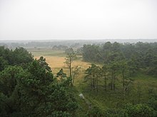
Kalmthout Heath
[1] It has been protected as a landscape since 1941, and officially became a state reserve (Dutch: staatsreservaat) in 1964 due to a petition of over 100,000 signatures.
[3] The heath is an infiltration area located in a cover sand region, in the north of the province of Antwerp.
Its relief consists mainly of clay sediments from the Early Pleistocene Kempen Formation.
[4] "De Vroente" is a NME-centre (Dutch: Vlaams Kennis- en Vormingscentrum voor Natuur & Milieu) of the Flemish Government located at the main entrance of the Kalmthout Heath, and is the main visitor centre for the cross-border park "De Zoom – Kalmthoutse Heide" which spans six thousand hectares.
[5] Because of the desiccation and dramatic reduction of biodiversity in "De Groote Meer" in Ossendrecht; in 2015, seven nature organisations advocated for buying lands of the agriculture enclave "The Steertse Heath" located on the Belgian territory of the Kalmthout Heath.