Kanawha Valley Campaign of 1862
Confederate leadership desired to regain control of the region and its valuable salt mines, and the river valley was seen as a source for new army recruits.
Cox left behind a small force of about 5,000 men, which was under the command of Colonel Joseph Andrew Jackson Lightburn and headquartered at Gauley Bridge.
Confederate leadership found out about the depleted force, and sent Major General William W. Loring to drive the remaining Union soldiers out of western Virginia.
[5] On August 14, 1862, Cox began moving his Kanawha Division to Washington as reinforcement for Major General John Pope's Army of Virginia.
[6] Exceptions to Cox's orders were about 5,000 troops left behind and put under the command of Colonel Joseph Andrew Jackson Lightburn.
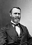
[11][Note 3] Colonel Joseph Andrew Jackson Lightburn assumed command of the District of the Kanawha, Department of the Ohio, on August 17, 1862.
Part of his plan included sending a cavalry force through 500 miles (800 km) of Union–controlled territory to cut off the Union route of retreat downriver.
[38] On August 22, he began the execution of his plan by sending north a cavalry force commanded by Brigadier General A. G.
[42] Jenkins' mission was to attack the Baltimore and Ohio Railroad and then move to the rear of the Union forces that occupied strategic points near the beginning of the Kanawha River.
[42] Jenkins' circular route began with a northern movement in the Cheat River Valley before moving west and south.
[49] This was the first Confederate invasion of Ohio, and the crossing was made near Ravenswood at Sand Creek Riffle in Meigs County.
[51] From there, he made a feint toward Point Pleasant, Virginia but took his command to the small town of Buffalo located up the Kanawha River.
[53] By August 31, Lightburn was aware of rumors that a Confederate force of 10,000 men was preparing to attack the Kanawha River Valley.
[54] Loring's Confederate force actually consisted of about 5,000 men instead the rumored 10,000, but he expected to add to it by recruiting and organizing existing local militias.
Unable to communicate with Loring, he eventually moved his men west toward the mouth of the Coal River (Kanawha County) in an attempt to block any Union retreat.
[60] In early September, Loring began moving toward the Union positions via the Princeton area, Flat Top Mountain, and then Raleigh Court House.
[10] Loring's men camped at McCoy's Mill (now Glen Jean, West Virginia) on the evening of September 9, which was about nine miles (14 km) south of Fayette Court House.
[71] Lightburn sent four companies from the 47th Ohio Infantry to assist Siber's First Brigade, and they met at the mountain top of Cotton Hill (between Fayetteville and the Kanawha River).
[72] However, the Union artillery force had been placed in a superior position, and drove the Confederates off the mountain despite a flanking movement.
During Siber's morning fighting, Gilbert positioned artillery on the north side of the Kanawha River at Montgomery Ferry.
The artillery and supporting forces totaled to less than 600 men, and they protected Siber's supply wagons as they ferried across the river.
[75] Although Gilbert's men set the ferry boat on fire and continued their retreat west, Confederate soldiers swam across the river and extinguished the blaze.
[77] Camp Piatt was a Union outpost on the Kanawha River about 10 miles (16 km) upriver (east) from Charleston.
He knew he was being pursued by Loring, and thought Major General John B. Floyd was moving his partisan force to a point downriver from Charleston (Coals Mouth) to cut off the Union retreat.
[93] The pursuit was soon abandoned, since they had left their supply trains behind earlier in their effort to catch the retreating Union army.
[97] On September 19, Union leaders attached Lightburn's force to the Department of the Ohio, which was commanded by Major General Horatio G.
[83] In early October, Cox was promoted to major general and sent back to Point Pleasant to retake the Kanawha River Valley.
[100] Citing lack of cooperation, Confederate leadership removed Loring from command on October 15, and his replacement was Major General John Echols.
[109] Wharton commanded a division in Jubal Early's Army of the Valley, fighting in battles such as Third Winchester, Fisher's Hill, and Cedar Creek.
The river would have been impassable, for all the ferry-boats were in the keeping of our men on the right bank, and Loring would not dare pass down the valley leaving a fortified post on the line of communications by which he must return.