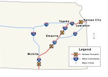
Kansas Turnpike
To reduce the risk of head-on collisions, the Kansas Turnpike now has a continuous, permanent Jersey barrier in the median over its entire length.
One of these service areas is notable for the presence of a memorial to University of Notre Dame football coach Knute Rockne, who died near the current highway's route.
[2] The turnpike is self-sustaining; it derives its entire revenue from the tolls collected and requires no additional tax money for maintenance or administration.
This trend started with the Pennsylvania Turnpike in 1940, which was mimicked by other toll roads in New York, New Jersey, several New England states, West Virginia, Ohio, and Colorado.
In October 1951, the Highway Council of the Kansas Chamber of Commerce researched the possibility of integrating the state into a potential cross-country turnpike system.
Governor Ed Arn and Gale Moss, the State Highway Director, were two major proponents of the turnpike concept.
[6] The turnpike idea was an attractive one because initial construction was to be financed by the private sector via sales of revenue bonds, allowing state highway funds to be used for other important projects.
There was also a concern that if Kansas lagged behind in turnpike construction, it might be bypassed by toll roads in other states, leaving it at an economic disadvantage.
[5] The toll concept also had the benefit of ultimately putting the financial burden on the drivers who actually used the road, instead of using tax revenue that had been collected from residents statewide.
The KTA sent out letters en masse to the affected landowners, offering a price and referring appeals to the local district court, which typically valued the land at a lesser amount; this methodology was not without criticism.
However, at the end of 1956, the Bureau of Public Roads and the state of Kansas agreed to route I-35 along the turnpike south of Emporia and I-70 along the piece east of Topeka.
The oat farmer plowed the field to provide a safer landing, and the KTA was persuaded to install a huge wooden barrier at the end of the highway.
But the fourth proposal, a toll bridge on 18th Street in Kansas City, was pushed through, and the KTA agreed to build the turnpike in early 1956.
The 18th Street Expressway, running south from the turnpike's east end over the Kansas River, opened in 1959, improving access to northeast Johnson County.
In the early 1960s, many senior positions in the KTA were cut, and, thanks to this and other austerity measures, such as targeting maintenance to save costs in the future, the turnpike slowly became profitable.
[16] By 1966, it was clear that the turnpike had not been built to the higher standards of the Interstate Highway System; the roadway had developed ruts and other issues due to deferred maintenance.
As economic conditions improved for the Authority, equipment was slowly replaced, and workers were given pay increases, both of which were badly needed.
A thunderstorm that evening dropped large amounts of rain in the area, with a gauge at Plymouth reporting 7.1 inches (18 cm) of rainfall in a 24-hour period.
The median barrier then gave way, sweeping the stalled cars across the southbound lanes and down the creek as far as 1.5 miles (2.4 km) from the highway.
Flash flooding along Slate Creek caused that tributary of the Arkansas River to inundate the turnpike four miles (6.4 km) south of the Wellington exit.
Tolls are instead paid using K-TAG (or compatible transponder) or via license plate recognition, which sends a bill to the vehicle's registered owner.
External bumper mounted transponders are alternatively available for purchase, intended for motorcycles and vehicles with specialty windshields that preclude proper functioning of the sticker tag.
If a motorist presented a ticket at the same toll plaza it was issued from, the KTA charged a "per-minute" fare if the trip was more than 15 minutes.
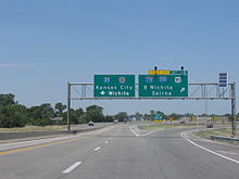
After passing the Bonner Springs interchange, exit numbers change to match the mileage of I-70 east from the Colorado border, which is also used on I-70 west of the turnpike.
Initially, the interchange provided only a southbound exit and northbound entrance,[48] forcing drivers who did not wish to pay a toll to leave I-35 in Oklahoma.
[51] The freeway takes a brief jog to the northeast before crossing over a Burlington Northern Santa Fe rail line southeast of Riverdale.
[44][67] As the highway continues northeast past El Dorado Lake, it runs roughly parallel to the Walnut River to the west, which feeds the reservoir, and K-177 to the east.
[52] Approximately 13.7 miles (22.0 km) northeast of the service area, an interchange provides access to a set of cattle pens southeast of Bazaar.
A series of curves takes the turnpike farther east as it reaches exit 197 (Lecompton[79]), a folded diamond interchange with the western terminus of K-10.
KTA broadcasts a travel radio station at 1610 AM from Wellington, Wichita, El Dorado, Cassoday, Emporia, Admire, East Topeka, and West Lawrence.