Pennsylvania Turnpike
[18][19] The turnpike heads east through a mixture of rural land and suburban development approaching Harrisburg, passing over Norfolk Southern's Shippensburg Secondary rail line.
[18][19] After joining I-95, the remaining three miles (4.8 km) of road uses I-95's mileposts and exit numbers and is not signed as the Pennsylvania Turnpike (although it is still considered part of the mainline).
[66] The PTC broadcasts AM road, traffic, and weather conditions from highway advisory radio transmitters at each exit on 1640 kHz, with a range of approximately two miles (3.2 km).
[86] Sunoco took over gas-station operations in 1993, outbidding Shell US;[87] credit card-activated pumps, fax machines, ATMs, and informational lodging boards were added.
The Oakmont Plum plaza was first (closing in 2006 and reopening the following year), and was followed by the reconstruction of the North Somerset and Sideling Hill plazas (2007–2008); New Stanton (2008–2009); King of Prussia (2009–2010); Lawn and Bowmansville (2010–2011); South Somerset, Blue Mountain, and Cumberland Valley (2011–2012); South Midway and Highspire (2012–2013); Peter J. Camiel (2013–2014); and Valley Forge and North Midway (2014–2015).
It began the previous night with a banquet at the Hotel Hershey and proceeded west along the turnpike, stopping at the Clear Ridge cut before lunch at the Midway service plaza.
[185] Commission chair Jones called for more limited-access roads to be built across the country for defense purposes,[178] and the turnpike was a model for a proposed national network of highways planned during World War II.
[188] The turnpike commission began looking into funding for this road in 1949, which would run from the Irwin Interchange to the Ohio state line near Youngstown and bypass Pittsburgh.
[209] The rest of the Philadelphia extension opened to traffic on November 20; the governor and chair Evans cut the ribbon at the Valley Forge mainline toll plaza west of King of Prussia.
[232][233] Groundbreaking for the Northeastern Extension occurred on March 25, 1954, in White Haven, with Governor John S. Fine and commission chair Thomas J. Evans present.
[234] In April 1954, $233 million (equivalent to $2.1 billion in 2023[110]) in bonds were issued to build the Northeastern Extension along with the Delaware River–Turnpike Toll Bridge on the mainline Pennsylvania Turnpike.
The interchange was initially left as is due to financial restraints, though when a man was killed in a car crash in 1963, funding was obtained,[254] and work began that October to replace it.
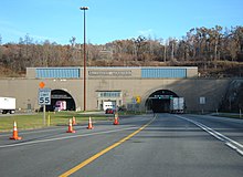
[11] As traffic levels increased at a rate almost ten times what PTC engineers originally anticipated, the two-lane tunnels became bottlenecks on the otherwise four lane road.
[citation needed] Contrary to early plans, the new interchange did not directly connect to the road, due to a study completed in 1966 determining such a move would not increase toll revenue.
In 1968, a PTC contractor proposed a project that would have rebuilt the eastern portion of the road from the Morgantown Interchange and the Delaware River Bridge in order to reduce congestion and limit stops at toll plazas as much as possible.
However, due to being too expensive, the PTC quickly scaled this down to relocation of the eastern terminus of the ticket system from the Delaware River Bridge Toll Plaza to the Morgantown Interchange.
[294] The project involved constructing a 1.5 miles (2.4 km) long access road with a diamond interchange leading to the new freeway, past there, it traveled to Pennsylvania Route 272, the former surface alignment.
[317] In 1989, construction began on a eastbound truck lane between the Beaver River Bridge and emergency pull off at milepost 15.5, Overpasses needed to be rebuilt to accommodate the work.
[320] Construction was delayed when an unsuccessful bidder challenged the commission that June, saying that it violated female and minority contracting rules about the percentage of employees that were used for the project.
[70] The Mid-County Interchange was opened to traffic in November 1992, witch allowed for closure and demolition of the original ramps onto the northeast Extension and completion of their replacements.
[365] The Warrendale Toll Plaza was delayed by a dispute with Marshall and Pine townships in Allegheny County, who thought that it would cause noise, air, and light pollution.
[70] In March 2007, the PTC announced that it had removed the steps leading to St. John's Church in New Baltimore because they were a safety hazard and violated interstate highway standards.
In November, work began on improvement of the Harrisburg East Interchange, its toll plaza was expanded to nine lanes, and its ramps replaced to accommodate the widened mainline.
[70] In November 2006, Governor Ed Rendell and Pennsylvania House Speaker John Perzel proposed leasing the turnpike long-term to a private group to raise money to improve other infrastructure in the state.
[456] Mainline toll gantries are planned to be in operation on January 5, 2025, from of the east of the Reading Interchange to the eastern end of the ticket system in Neshaminy Falls.
[467] An environmental impact statement (EIS) was released in 2003, with this it was revealed that the project would also included widening and a new eastern end of the ticket system to be located before the interchange.
[citation needed] Long-term plans call for the construction of missing connections with I-95 and I-295, as well as and widening the turnpike to six lanes between the Bensalem interchange and New Jersey state line.
This would include the reconstruction of the exit 42's ramps from and off of the turnpike, as well a replacement of the Delaware River Bridge with a new span, which is expected to begin construction in 2025 at the earliest.
[citation needed] On September 24, 2024, the PTC announced plans to widen the stretch between mileposts 160 and 163 to six lanes; this would also involve replacement of the Breezewood interchange to add a connection between the turnpike and I-70.
[495] The new alignment will include an overpass for use by wildlife that use the forests above the tunnel, and a new underpass would be built to replace the existing culvert at the Raystown Branch Juniata River.