Kasaragod
Robert Caldwell describes the extent of Malayalam in the 19th century as extending from Chandragiri (fort and river) in the north to Neyyar river beyond Thiruvananthapuram in the south and from Malabar Coast in the west to Western Ghats in the east besides the inhabited islands of Lakshadweep in the Arabian Sea.
[14][15][16][17] The ancient Tamil works of the Sangam Age record that the area covering the district was part of Puzhinadu which consists of the coastal belt from Kozhikode to Mangalore.
The most famous king of Ezhimala was Nannan whose kingdom extended up to Gudalur and northern parts of Coimbatore.
The Kolathunad Kingdom at the peak of its power reportedly extended from Netravati River (Mangalore) in the north[18] to Korapuzha (Kozhikode) in the south with Arabian Sea on the west and Kodagu hills on the eastern boundary, also including the isolated islands of Lakshadweep in Arabian Sea.
[19] Kasaragod, about 50 km south of Mangalore city, was an important centre of trade in earlier times.
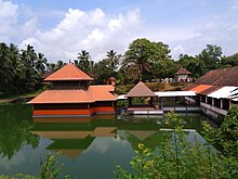
Ramacharitam, probably the oldest literary work written in Old Malayalam, which dates back to the 12th century CE, is thought to have written in Kasaragod district as its manuscripts were discovered from Nileshwaram and the poem mentions about Ananthapura Lake Temple in Kumbla in detail.
Duarte Barbosa, a Portuguese traveler who visited Kumbla, near Kasaragod Town in 1514 recorded that rice being exported for coir to Maldives.
[14] According to Barbosa, the people in the southwestern Malabar coast of India from Chandragiri in the north to Kanyakumari in the south spoke a unique language, which they called as "Maliama" (Malayalam).
[23][24] Until the 16th century CE, Kasaragod town was known by the name Kanhirakode (may be by the meaning, 'the land of Kanhira trees') in Malayalam.
[11] The Kumbla dynasty, who swayed over the land of southern Tulu Nadu wedged between Chandragiri River and Netravati River (including present-day taluks of Manjeshwar and Kasaragod) from Maipady Palace at Kumbla, had also been vassals to the Kolathunadu kingdom of North Malabar, before the Carnatic conquests of Vijayanagara Empire.
[13] Francis Buchanan-Hamilton states that the customs of Kumbla dynasty were similar to those of the contemporary Malayali kings.
[13] The Kolathiri Dominion emerged into ten independent principalities, i.e. Kadathanadu (Vadakara), Randathara or Poyanad (Dharmadom), Kottayam (Thalassery), Nileshwaram, Iruvazhinadu (Panoor), Kurumbranad etc., under separate royal chieftains due to the outcome of internal dissensions.
[26] Many portions of the present-day Hosdurg taluk (Kanhangad) and Vellarikundu were parts of the Nileshwaram dynasty, who were relatives to both Kolathunadu as well as Zamorin of Calicut, in the early medieval period.
[27] The areas north to the Chandragiri river (present-day Taluks of Manjeshwaram and Kasaragod) were ruled by the Kumbala dynasty.
[14] In his travelogue, he recorded information on places like Athiraparambu, Kavvayi, Nileshwaram, Bekal, Chandragiri and Manjeshwar.
[14] it is said that Kinavoor Molom (Sree Dharma Shashtha Temple) is belonging to Karinthalam (one of 64 Brahmin villages in old Kerala).
[32] Before the formation of Kerala, Kasaragod was a part of South Canara district of erstwhile Madras Presidency.
The inclusion of Kasaragod with Kerala has been a contentious issue as there is a sizeable population that speaks Tulu and Kannada.
[34] But it is noted that as per the 2011 census report only 8.8% and 4.2% of the total population in the district speak Tulu and Kannada respectively as their mother tongue.
The National Highway 66 which connects the western coast of India from Mumbai to Kanyakumari passes through coastal area of the district connecting the major coastal towns of Manjeshwar, Uppala, Kumbla, Kasaragod, Udma, Bekal, Kanhangad, Nileshwaram, and Thrikaripur.
[50] The Kerala State Road Transport Corporation (KSRTC) has stations to operate its service in the district.
Indian National Congress (INC) member Rajmohan Unnithan is the present MP from Kasaragod (2019 elections).