Kazungula
Kazungula is a small border town in Zambia, lying on the north bank of the Zambezi River about 70 kilometres (45 mi) west of Livingstone on the M10 Road.
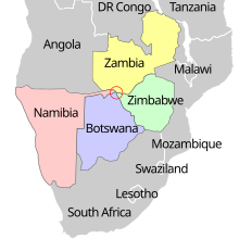
The ever-shifting river channels and the lack of any agreements addressing the issue before 2000 led to some uncertainty in the past as to whether or not a quadripoint legally existed.
[5] In April 2014, Zimbabwe's then Transport Minister Obert Mpofu was asked in Parliament about the Kazungula Bridge being built by Botswana and Zambia.
This was confirmed by Botswana's then Minister of Transport and Communications, Nonofo Molefi, in September 2014: "we approached Namibia and asked that the bridge pass through their territory and they agreed.
The district is covered by one parliamentary constituency and fourteen political wards which include Sikaunzwe, Sekute, Nwezi, Moomba, Nyawa, Nuba, Kauwe and Chooma.
The major activity in the secondary sector is the generation of power at Batoka Gorge located in Mukuni ward.
There are 10,522 small-scale farmers farming a wide range of crops such as maize, sorghum, millet, groundnuts and cotton.
The crops grown by these farmers include but not limited to maize, sorghum, millet, groundnuts, cotton, cassava and vegetables.
There are a number of livestock species that are reared in Kazungula District but the notable ones include cattle, goats, sheep, donkeys, poultry and pigs.
The annual loss of forest cover was estimated at 1.2% due to land clearing for agricultural use rather than energy purposes.