River Avon, Bristol
[1] The name "Avon" is loaned from the Common Brittonic abona, "river", which survives in the Welsh word afon [ˈavɔn].
The Avon rises on the southern edge of the Cotswold hills, at Didmarton in Gloucestershire;[4] at Joyce's Pool a plaque marks the source.
The two rivers flow north and south of a rocky outcrop, almost creating an island for the ancient hilltop town of Malmesbury to sit on.
[19][20] The stretch of river below and above the aqueduct, where it is joined by Midford Brook, has been used by rowing crews from Monkton Combe School since at least the beginning of the 1900s.
From here, cranks drive vertical connecting rods which transfer the energy to two 18 ft (5.5 m) long cast iron rocking beams.
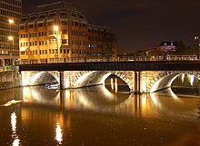
Cleveland Bridge was built in 1826 by William Hazledine,[24] owner of the Coalbrookdale Ironworks, with Henry Goodridge as the architect,[25] on the site of a Roman ferry crossing.
It was designed by architect Henry Goodridge to take the traffic of his day, horse-drawn vehicles and pedestrians, and was constructed using Bath Stone and a cast iron arched span.
[27] Bath and North East Somerset council have discussed plans to ban vehicles from the bridge and turn it into a pedestrianised zone,[28] but it remains open to buses and taxis.
[29] Some 700 metres below Pulteney weir, the river is joined by the Kennet and Avon Canal which connects through Bath Locks.
Together with the Kennet Navigation which joins the River Thames at Reading, this provides a through route for canal boats from Bristol to London.
The river is joined by the Siston Brook at Londonderry Wharf, terminus of the dramway which brought coal from Coalpit Heath.
Construction started in 1804 to build the tidal New Cut, where it is joined by the River Malago, and divert the Avon along the Feeder Canal to the harbour; a system designed and built by William Jessop and later improved by Isambard Kingdom Brunel.
[37] The original course is held at a constant level by lock gates (designed by Jessop) and is known as the floating harbour, since it enables ships to stay afloat rather than grounding when the tide ebbs.
As a result of this, the floating harbour is one of the more successful pieces of dockland regeneration, with much of the dockside now occupied by residential, office and cultural premises, and the water heavily used by leisure craft.
Before reaching its mouth, the Avon is joined by the River Trym at Sea Mills which was the site of Portus Abonae, a Roman port.
The Avonmouth Docks are on the north side of the river and are one of the UK's major ports for chilled foods, especially fruit and vegetables.
The main reasons for not achieving good scores are pollution from waste water, agriculture and rural land management.
The pollution from upstream is added to by the effects of industry, manufacturing and other businesses and is significantly affected by physical modifications to the water course.
In conjunction with other sites within the wider area, it has aided the development of a scientific understanding of the history of early glaciation within South West England.
[68] Newton St Loe SSSI is also listed for geological reasons as it represents the only remaining known exposure of fossiliferous Pleistocene gravels along the River Avon.
In conjunction with other sites within the wider area, they have aided the development of a scientific understanding of the history of early glaciation within South West England.
[60] At Horseshoe Bend, Shirehampton the wooded cliff and a narrow salt marsh are supported by rocks of Devonian age Old Red Sandstone and Carboniferous Limestone, overlain by with Triassic dolomitic conglomerate.
The site's principal interest and the reason for its designation as an SSSI is the presence of a population of the true service-tree (Sorbus domestica) growing on the cliffs.
The nationally scarce large-leaved lime (Tilia platyphyllos) also occurs, and herbs include field garlic (Allium oleraceum) and pale St. John's-wort (Hypericum montanum).
There are however two nationally scarce vascular plant species here as well – slender hare's-ear (Bupleurum tenuissimum) and long-stalked orache (Atriplex longipes).
[74] Navigation conservancy in the lower river from Avonmouth to the lock at Hotwells is the responsibility of The Bristol Port Company as both statutory and competent harbour authority.
[76] The distribution of archaeological finds suggests that the western end of the river between Bath and Avonmouth formed a border between the Dobunni and Durotriges during the late Iron Age, prior to the Roman conquest of Britain.
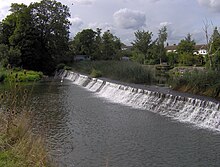
[79] The river, once an unnavigable series of braided streams broken up by swamps and ponds, has been managed by weirs into a single channel.
The Bristol Channel has a very high tidal range of 15 metres (49 ft),[84] second only to Bay of Fundy in Eastern Canada;[85][86] and the gorge is relatively narrow and meandering, making it notoriously difficult to navigate.
Several vessels have grounded in the gorge including the SS Demerara soon after her launch in 1851, the schooner Gipsy in 1878, the steam tug Black Eagle in 1861 and the Llandaff City.