Bang Rak district
It lies on the eastern bank of the Chao Phraya River, beyond Khlong Phadung Krung Kasem, which marked the old city boundary.
Originating from riverside settlements dating from before the city's foundation, Bang Rak grew inland as new roads and canals were constructed through the area during the second half of the nineteenth century and the early twentieth, attracting communities of expatriates and developing into a major commercial district.
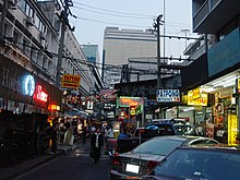
Bangkok's rapid economic growth in the late twentieth century saw the areas along Si Lom and Sathon roads transformed into one of the city's main business districts, teeming with skyscrapers.
Up until the mid-nineteenth century, water formed the primary mode of transport in the lower Chao Phraya plains, and most people lived along the banks of rivers and canals.
Settlements had formed along the Chao Phraya River since the Ayutthaya Kingdom (14th century – 1767), and some Buddhist temples in and around Bang Rak date to the period.
Downstream of the city and just beyond the Chinatown area, the waterfront stretch that is now Bang Rak Subdistrict was home to Thais, Chinese, Vietnamese, Malays, Lao, Tavoyans, and descendants of Portuguese, among others.
[3] European expatriates petitioned Mongkut to build roads for their use, first to the Phra Khanong area (to where they planned to relocate but later abandoned the idea), then to serve the waterfront community in Bang Rak.
[8] Bang Rak District gradually proceeded to fill up with development, and in the post-World War II period, increasing numbers of foreign businesses moved from the waterfront area into newer premises, especially along Si Lom Road.
In 1963, the trams were discontinued, and the canal that ran alongside Si Lom road was filled in for its expansion, further incentivizing its development as a business street.
Today, as rak is also a homonym alternatively meaning "love", the name makes the district office a popular place for marriage registrations, especially on Valentine's Day.
[12] Bang Rak District occupies 5.536 square kilometres (2.137 sq mi) in Bangkok's Phra Nakhon side, on the east bank of the Chao Phraya River.
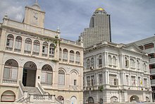
[16] The flurry of activity, however, doesn't reach the waterfront area along Charoen Krung Road (mostly covered by Bang Rak Subdistrict), which retains much of its historic architecture.
The area's side streets, such as Soi Charoen Krung 36 and Captain Bush Lane, feature heritage buildings that serve as cultural tourism destinations.
[17][18][19][20] Among the best known features of Bang Rak District are the skyscrapers of Si Lom and Sathon, some of which—Mahanakhon, State Tower, and Jewelry Trade Center—are among the tallest buildings in the country.
They stand in contrast to colonial-era historic buildings such as the Neilson Hays Library and the British Club on Surawong Road, and the Sathon Mansion near Sathon–Naradhiwas Intersection.
[6][22] The influence of the Christian missionaries is clearly observable in Bang Rak, not least from their churches—the Assumption Cathedral near the river is the seat of the Roman Catholic Archdiocese of Bangkok, while over a dozen Protestant churches are located in the district—but also through the schools and hospitals they founded.
The MRT runs under Rama IV Road along the district's northern border, with Hua Lamphong, Sam Yan, Si Lom (at Sala Daeng Intersection), and Lumphini (at Witthayu) stations serving the respective neighbourhoods.