Kimberley (Western Australia)
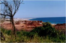
It is bordered on the west by the Indian Ocean, on the north by the Timor Sea, on the south by the Great Sandy and Tanami deserts in the region of the Pilbara, and on the east by the Northern Territory.
The region was named in 1879 by government surveyor Alexander Forrest after Secretary of State for the Colonies John Wodehouse, 1st Earl of Kimberley.
[4] The worship of Wandjina deities was most common in this region, and a complex theology dealing with the transmigration of souls was part of the local people's religious philosophy.
In 1837, with expedition support from the Royal Geographical Society of Great Britain, Lieutenants George Grey and Franklin Lushington and 12 men sailed on the schooner Lynher from Cape Town, South Africa.
[7][8] In 1879, Western Australian government surveyor Alexander Forrest led a party of seven from the west coast at Beagle Bay to Katherine, Northern Territory.
[10] In 1881, Philip Saunders and Adam Johns, in the face of great difficulties and dangers, found gold in various parts of the Kimberley.
Early in 1881, the first five graziers, who called themselves the Murray Squatting Company, took up 49,000 hectares (120,000 acres) behind Beagle Bay and named it Yeeda Station.
Additional Anglo-European settlement occurred in 1885, when ranchers drove cattle across Australia from the eastern states in search of good pasture lands.
After returning to Japan in February, the junior officer, who had commanded the party, suggested using 200 Japanese prison inmates to launch a guerrilla campaign in Australia.
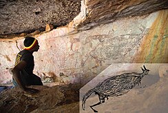
[16] Considering the area's size, it is no surprise that there are tens of thousands of rock art examples coming from a variety of different cultural groups within the region.
The earliest form of Kimberley rock art was hand stencils,[19] but techniques such as engraving, painting, scratchwork, pecking, drawing, and later beeswax applique[20] have also been used.
In addition to the varying styles and techniques, there are united visual depictions that reflect the changes and persistence within the cultural and natural environment.
[21]The changing and expanding complexity of styles and techniques has caught the attention of many, paving the way for mass amounts of archaeological and anthropological research.
[23] A rock shelter in Kimberley's northeastern territory is home to a perfect example of this, a two-meter-long kangaroo painting on the ceiling.
[23][24] Based on oral accounts from Aboriginal people in the region[20] it has been confirmed that many of the works that have been re-touched maintain a much deeper significance.
Creation stories, migrational patterns, and clothing style of the figures emphasise their importance and integration into the sociocultural groups inhabiting the area.
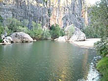
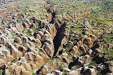
The Kimberley consists of the ancient, steep-sided mountain ranges of northwestern Australia cut through with sandstone and limestone gorges and steep ridges, from which the extreme monsoonal climate has removed much of the soil.
In parts of the Kimberley, such as the valleys of the Ord and Fitzroy Rivers in the south, the soils are relatively usable cracking clays, whilst elsewhere they are lateritic Orthents.
The region receives about 90% of its rainfall during the short wet season, from November to April, when cyclones are common (especially around Broome) and the rivers flood.
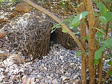
The rugged and varied sandstone landscape is home to a distinctive mixture of wildlife, which has been thoroughly mapped and described by the Western Australian Department of Conservation and Land Management.
[33][34][35][36][37][38][39][40][41][42][43][excessive citations] There are habitats similar to the Kimberley across the border in the Northern Territory, including the valleys of the Victoria and Daly Rivers but these have been less carefully studied.
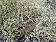
Mammals that have declined especially in the flatlands include the bilby, northern quoll, pale field rat, golden-backed tree-rat, and golden bandicoot.
Little of the Kimberley has been subject to wholesale clearance other than particularly fertile parts of the Ord Valley (and areas of Kimberley-type habitat across in the Daly River basin in the Northern Territory) but the pastureland in the southern areas has been affected by 100 years of livestock grazing and other threats including introduced weeds (such as cocklebur, parkinsonia, bellyache bush and castor oil plant), feral cats and changes to traditional Aboriginal fire regimes (the way grassland is burnt and allowed to renew).
In 2012 the Western Australian government announced the creation of the 7,062 square kilometre Camden Sound Marine Park with a further three to come.
Woodside Energy, with the additional involvement of BHP and the Government of Australia, has sought to build a gas industrial complex, and those in opposition believe that such a development threatens the region.
The campaign has received support from public figures such as John Butler, Clare Bowditch, Missy Higgins and former leader of the Australian Greens, Bob Brown.
On 5 October 2012, a concert was held at Federation Square in Melbourne, Australia, to raise awareness of the campaign; the protest event attracted approximately 6,000 people.
On 24 February 2013, an estimated 20,000 people gathered for a charity concert[51] in Fremantle, Western Australia to raise awareness and funds to help protect the Kimberley, with performances from Ball Park Music, Missy Higgins, and John Butler.
Issues have been raised regarding the exploitation of indigenous artists by businesses and individuals, including in the Kimberley, which were canvassed in an Australian Senate parliamentary committee report.