Kinnickinnic River (St. Croix River tributary)
This ORW designation indicates the Kinni provides outstanding recreational opportunities, supports valuable fisheries and wildlife habitat, has good water quality, and is not significantly impacted by human activities.
[4] This designation indicates that the State of Wisconsin has determined the Kinnickinnic River warrants additional protection from the effects of pollution.
The name Kinnickinnic is a word from the Ojibwe giniginige, and refers to tobacco mixed with other plant material for smoking.
He first settled in the area over the winter of 1848-1849 in a walled-in cave overhang at the confluence of the main channel and the South Fork of the Kinnickinnic River.
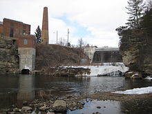
Foster built a sawmill and dam in 1854 which was later expanded to include a feed store and was located on the south bank of the Kinnickinnic River.
The extreme case of this is near the delta, where the water becomes even warmer, and the river supports warmer-water species such as smallmouth bass.
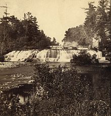
The Kinni watershed is characterized by scenic bluff lands, rare oak savanna, original prairie, farm land, white pine forest, wooded coulees, sedge meadows, rare and endangered plant species, beautiful stands of white pines and plenty of open space and scenic vistas.
Its feeder creeks are cold and clean, containing wild native brook trout, important spawning areas, wetlands, and many springs arising from under picturesque limestone outcroppings.
[11] In February 2018, the River Falls city council unanimously approved a plan to decommission and remove the dams.