Neckar
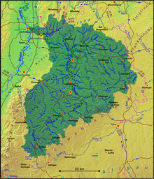
The Neckar (German pronunciation: [ˈnɛkaʁ] ⓘ) is a 362-kilometre-long (225 mi) river in Germany, mainly flowing through the southwestern state of Baden-Württemberg, with a short section through Hesse.
Rising in the Schwarzwald-Baar-Kreis near Schwenningen in the Schwenninger Moos conservation area at a height of 706 m (2,316 ft) above sea level, it passes through Rottweil, Rottenburg am Neckar, Kilchberg, Tübingen, Wernau, Nürtingen, Plochingen, Esslingen, Stuttgart, Ludwigsburg, Marbach, Heilbronn and Heidelberg, before discharging on average 145 m3/s (5,100 cu ft/s) of water into the Rhine at Mannheim, at 95 m (312 ft) above sea level, making the Neckar its 4th largest tributary, and the 10th largest river in Germany.
Since 1968, the Neckar has been navigable for cargo ships via 27 locks for about 200 kilometres (120 mi) upstream from Mannheim to the river port of Plochingen, at the confluence with the Fils.
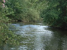
Between Stuttgart and Lauffen, the Neckar cuts a scenic, meandering, and in many places steep-sided, valley into fossiliferous Triassic limestones and Pleistocene travertine.
With this junction above Rottweil the Neckar enters a narrow, wooded valley and for the next 80 km it bores its way towards north between the ranges of the Black Forest and the Swabian Jura.
Between Stuttgart and Lauffen the Neckar cuts a scenic, meandering, and in many places steep-sided, valley into fossiliferous Triassic limestones and Pleistocene travertine.
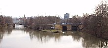
At the last of his distinctive knees at Eberbach it turns west, enters at Hirschhorn for a short distance Hessian territory and is then up to Neckarsteinach on long parts the border between Baden-Württemberg and Hessen.
At Neckargemünd the Elsenz enters from the left, its lower reaches using a part of the Neckars former Maurer river loop which extended far south.
Therefore, according to hydrographic convention, the Lein would have to be regarded as the main river of the Kocher water system, making it with then 201 kilometers the longest tributary of the Neckar.
Following that the Neckar cut into the Muschelkalk plateau between Rottweil and Rottenburg as well as the younger Keuper and Jura layers in the northeast, and created narrow water gaps in the area of the morphologically hard chalks and sandstones.
Until 2000 years ago the Neckar flowed through a pastureland in the Oberrheinische Tiefebene in a tangle of meanders, slings,[clarification needed] old waters[clarification needed] and cut of arms between the Rhine in the west and the foot of the Odenwald in the east until it finally entered the Rhine only north of Darmstadt at Trebur; roughly 50 km north of today's confluence in Mannheim.
Wide valley meadows also developed through the strong backfilling with Aue clay since the start of settlement in the Neolithic and the accompanying deforestation and soil erosion.
Gravel pit quarrying in the valley plains takes away agricultural land, but created large lakes, nowadays used for recreational purposes.
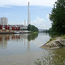
One example is the densely populated and industrialised Neckar valley between Plochingen and Bad Cannstatt, which harbors large companies such as Daimler AG (the maker of Mercedes Benz cars) and Mahle GmbH and recreational facilities with large area consumption like the MHPArena, the Hanns-Martin-Schleyer-Halle or the Cannstatter Wasen, the second-largest fair of Germany.
The diverse usage of raw water and waterway, as well for the production of hydropower brought with it substantial interventions into the ecological structure of the river.
At an oxygen content of below 4 mg/L power plant owners have to run specially designed turbines to inject air into the water.
The Neckar privilege granted by Holy Roman Emperor Louis IV in 1333 allowed the free imperial city the construction of a weir.
In 1342 Württemberg, the Markgrafschaft Baden and the free imperial city signed an agreement for the opening of the Neckar for rafts between Besigheim and Heilbronn.
[7] After consolidation of the situation in the 18th century, electoral palatinate market ships regularly travelled on the lower Neckar river.
On the upper Neckar boats regularly travelled between Heilbronn and Cannstatt for several years around 1720; the expansion of the navigation to the Württembergian Plochingen further up the river failed due to the free imperial city of Esslingen.
Württemberg and the Electoral Palatinate signed a trade agreement in order to start up the Neckar navigation between Mannheim and Cannstatt during a time of economical rise in the late 18th century.
On the one hand – because most parts of the lower Neckar area had fallen to Baden and the free imperial cities of Heilbronn and Esslingen to Württemberg – the many disputes and obstructions of the former small states did not hamper the trade anymore.
The competition of rail transport made steam ships as well as towing barges gradually uneconomic in the second half of the 19th century.
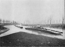
Between Mannheim and Heilbronn steam towboats with attached barges were now able to pull themselves upriver on a 115 km long chain which had been put into the river.
The world's first motorboat made during the summer of 1886 by Gottlieb Daimler and Wilhelm Maybach was named "Neckar" when their Standuhr (grandfather clock) petrol engine was tested on the river near Bad Cannstatt.
In order to provide the rising industrial area around Stuttgart a waterway connection for fully rigged ships, first plannings for channelling of the Neckar between Mannheim and Plochingen began already in 1904.
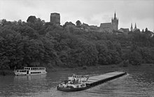
In consideration of the world famous cityscape of Heidelberg and in order to bring the further barrages in unison with nature and landscape, the architect Paul Bonatz worked for the project (1877–1956).
In total only 17% of the entire distance from the Rhine up to the mouth of the Rems lie in an artificial waterbed, which means the river character dominates.
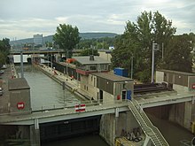
The waterway depth is since 2000 continuously 3.80 m. This means that the Stuttgart harbour can be reached by the large motor ships of the Rhine, which have a draft of 2.6 m and a loading capacity of 2200 t. In the coming years it is planned to refurbish the locks and partly extend them.
In order to keep water level differences caused by the barrage, a ridge was constructed about 100 m below the Plochingen street bridge and moved the gauge there.