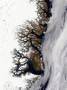
Kjerulf Fjord
[2] The fjord was first mapped by Julius Payer during the 1869–1870 Second German North Polar Expedition led by Carl Koldewey (1837–1908).
Louise Boyd noted the large amount of massive stranded icebergs in the fjord during an exploration in 1931.
Its mouth opens to the north on the southern shore of the main fjord, only about 7 km (4.3 mi) east of the terminus of the Nordenskiöld Glacier (Akuliarutsip Sermerssua) at its head.
Ridderborgen (Knight Mountain), a 1,885 m (6,184 ft) high peak topped by a rock pinnacle resembling a ruined castle, rises on the west side of the mouth area of the fjord.
Kjerulf Fjord has been described as an "iceberg graveyard", for many glaciers originating in the Isfjord to the north, end up stranded here driven by the wind and currents.