Knapdale
Possible boundary changes make historic comparisons for South Knapdale less certain, but this part of the region appears not to have suffered the same depopulation as the north, and even modest growth, a rise from around 1750 in 1801 to around 2700 in 1901.
[9] In the early first millennium, following an Irish invasion, Gaelic peoples colonised the surrounding area, establishing the kingdom of Dál Riata.
Dunadd, the capital of Dál Riata, was located in this region, slightly to the north of the modern day limit of Knapdale, in what was then marshland.
This Gaelic kingdom thrived for a few centuries, but was ultimately destroyed when Norse Vikings invaded, and established their own domain, spreading more extensively over the islands north and west of the mainland.
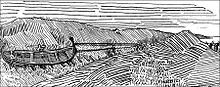
The unspecific wording led Magnus to have his boat dragged across the narrow isthmus at Tarbert, while he rode within it, so that he would thereby acquire Kintyre, in addition to the more natural islands of Arran and Bute.
In the mid 12th century, Somerled, the husband of Godred Crovan's granddaughter, led a successful coup, and seized the kingship of the Isles.
In 1262, following increasing hostility between Norway and Scotland, the Scots forced Suibhne's heir, Dubhghall, to give up his lands - including Knapdale - to Walter Stewart, Earl of Menteith.
When de Bruys defeated John, he declared the MacDougall lands forfeit, and gave them to the MacDonalds; the MacSweens largely became gallowglass mercenaries in Ireland.
After 4 years and 3 children, he divorced Amy, and married Margaret, the daughter of Robert II, the Scottish king, who gave him Knapdale as a dowry.
In 1462, however, John, the then Lord of the Isles, plotted with the English king to conquer Scotland; civil war in England delayed the discovery of this for a decade.
Upon the discovery, in 1475, there was a call for forfeiture, but a year John calmed the matter, by quitclaiming Ross (Easter, Wester, and Skye), Kintyre, and Knapdale, to Scotland.
When the comital powers were abolished by the Heritable Jurisdictions Act, provincial Knapdale ceased to exist, and the term came to exclusively refer to the present district, south of Lochgilphead.
During the 1930s, the Ministry of Labour supplied the men from among the unemployed, many coming from the crisis-hit mining and heavy industry communities of the Central Belt.
The hutted camp in Knapdale was located at Cairnbaan, just south of the Crinan Canal, and a surviving building remains in use as a Forestry and Land Scotland workshop.
[citation needed] Further early Christian and Medieval carved stones can also be found at Kilberry,[17] and at the thirteenth century Kilmory Knap Chapel.
[22] Taynish National Nature Reserve is situated within North Knapdale, lying southwest of the village of Tayvallich on the west side of Loch Sween.