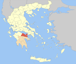
Corinthia
The eastern coastlands of Corinthia are made up of pastures and farmlands where olives, grapes, tomatoes and vegetables are cultivated.
Large concentrations of those descendants live especially in mountainous regions, including Xylokeriza, Examilia, Sophiko and Kyras Vryse.
The mid to late-20th century saw the population shifting from agriculture to other jobs, as people migrated to larger towns and cities as well as other parts of the world.
In the 1960s, the motorway GR-8A was constructed to handle the increasing traffic between Corinth and Athens and allow higher speed limits (60 to 80 km/h (37 to 50 mph)).
The new highway had a significant effect on the local industry, as it lowered the cost of transportation of goods between Corinthia and the Athens metropolitan area.
In late 2006, the prefect of Corinthia announced the construction of a new dam, to be located 5 to 7 km (3.1 to 4.3 miles) south of Kiato and Sicyon, near Stimanika, over the Elissos River.
On July 17, 2007, a forest fire struck the area around the historic Acrocorinth and its castle.