Bangkok
[5] Bangkok traces its roots to a small trading post during the Ayutthaya Kingdom in the 15th century, which eventually grew and became the site of two capital cities, Thonburi in 1767 and Rattanakosin in 1782.
The city was at the centre of the country's political struggles throughout the 20th century, as Siam—later renamed Thailand—abolished absolute monarchy, adopted constitutional rule, and underwent numerous coups and several uprisings.
Although its boundaries are at the provincial (changwat) level, unlike the other 76 provinces Bangkok is a special administrative area whose governor is directly elected to serve a four-year term.
Ground water management and mitigation measures have since lessened the severity of the situation, and the rate of subsidence decreased to 10 to 30 mm (0.39 to 1.18 in) per year in the early 2000s, though parts of the city are now 1 m (3 ft 3 in) below sea level.
[40] The city now relies on flood barriers and augmenting drainage from canals by pumping and building drain tunnels, but parts of Bangkok and its suburbs are still regularly inundated.
[43][44][45] A study published in October 2019 in Nature Communications corrected earlier models of coastal elevations[46] and concluded that up to 12 million Thais—mostly in the greater Bangkok metropolitan area—face the prospect of annual flooding events.
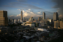
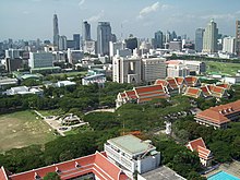
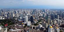
[9] The city has grown from its original centre along the river into a sprawling metropolis surrounded by swaths of suburban residential development extending north and south into neighbouring provinces.
While most of Bangkok's streets are fronted by vernacular shophouses, the largely unrestricted building euphoria of the 1980s has transformed the city into an urban area of skyscrapers and high rises of contrasting and clashing styles.
[72] Green belt areas include about 700 km2 (270 sq mi) of rice paddies and orchards on the eastern and western edges of the city, although their primary purpose is to serve as flood detention basins rather than to limit urban expansion.
[4] Bangkok is a cosmopolitan city; the census showed that it is home to 567,120 expatriates from Asian countries (including 71,024 Chinese and 63,069 Japanese nationals), 88,177 from Europe, 32,241 from the Americas, 5,856 from Oceania and 5,758 from Africa.
[l] Bangkok's cultural pluralism dates back to the early days of its founding: several ethnic communities were formed by immigrants and forced settlers including the Khmer, northern Thai, Lao, Vietnamese, Mon and Malay.
Likewise, Assumption Cathedral on Charoen Krung Road is among many European-style buildings in the Old Farang Quarter, where European diplomats and merchants lived in the late 19th to early 20th centuries.
Many multinational corporations base their regional headquarters in Bangkok due to the lower cost of labour and operations relative to other major Asian business centres.
[97] Income inequality is a major issue in Bangkok, especially between relatively unskilled lower-income immigrants from rural provinces and neighbouring countries, and middle-class professionals and business elites.
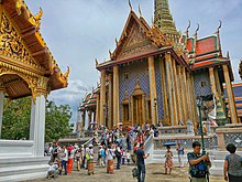
Vimanmek Mansion in Dusit Palace is famous as the world's largest teak building, while the Jim Thompson House provides an example of traditional Thai architecture.
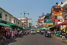
Khao San Road has long been famous as a destination for backpacker tourism, with its budget accommodation, shops and bars attracting visitors from all over the world.
Although prostitution is technically illegal and is rarely openly discussed in Thailand, it commonly takes place among massage parlours, saunas and hourly hotels, serving foreign tourists as well as locals.
Although they take up pavement space and block pedestrian traffic, many of the city's residents depend on these vendors for their meals, and the BMA's efforts to curb their numbers have largely been unsuccessful.
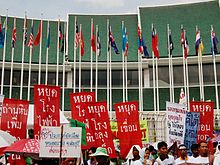
[114] In 2015, however, the BMA, with support from the National Council for Peace and Order (Thailand's ruling military junta), began cracking down on street vendors in a bid to reclaim public space.
[115] While some applauded the efforts to focus on pedestrian rights, others have expressed concern that gentrification would lead to the loss of the city's character and adverse changes to people's way of life.
The Red Cross Fair at the beginning of April is held at Suan Amporn and the Royal Plaza, and features numerous booths offering goods, games and exhibits.
These include the mass-oriented Thai Rath, Khao Sod and Daily News, the first of which currently prints a million copies per day,[122] as well as the less sensational Matichon and Krungthep Thurakij.
The centrally located Bangkok Art and Culture Centre, opened in 2008 following a fifteen-year lobbying campaign, is now the largest public exhibition space in the city.
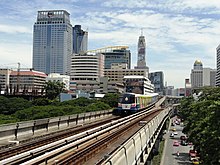
Bangkok is connected to the rest of the country through the national highway and rail networks, as well as by domestic flights to and from the city's two international airports (Suvarnabhumi and Don Mueang).
The extent of the problem is such that the Thai Traffic Police has a unit of officers trained in basic midwifery in order to assist deliveries which do not reach hospital in time.
[134] In January–February 2018, weather conditions caused bouts of haze to cover the city, with particulate matter under 2.5 micrometres (PM2.5) rising to unhealthy levels for several days on end.
[135][136] Although the BMA has created thirty signed bicycle routes along several roads totalling 230 kilometres (140 mi),[137] cycling is still largely impractical, especially in the city centre.
Poor surface maintenance, encroachment by hawkers and street vendors, and a hostile environment for cyclists and pedestrians, make cycling and walking unpopular methods of getting around in Bangkok.
[144][145] Bangkok is the location of Krung Thep Aphiwat Central Terminal, the new main terminus of the national rail network operated by the State Railway of Thailand (SRT).
In the 2000s, the Thaksin Shinawatra administration assigned the Office of the National Economic and Social Development Council (NESDC) to formulate a plan to move the capital to Nakhon Nayok province.


