Cooch Behar district
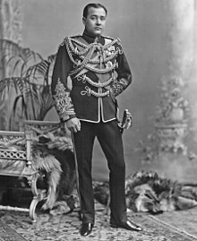
During the British Raj, the district was known as Cooch Behar state ruled by the Koch dynasty until 1949, when it became part of India.
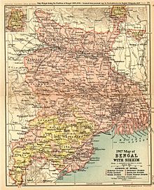
The district consists of the flat plains of North Bengal and has several rivers: the most notable being the Teesta, Jaldhaka and Torsa.
In the 12th century, the area became a part of the Kamata Kingdom, first ruled by the Khen dynasty from their capital at Kamatapur.
The Khens were an indigenous tribe, and they ruled till about 1498 CE, when they fell to Alauddin Hussain Shah, the independent Pathan Sultan of Gour.
The new invaders fought with the local Bhuyan chieftains and the Ahom king Suhungmung and lost control of the region.
[7] Nara Narayan's younger brother, Shukladhwaj (Chilarai), was a noted military general who undertook expeditions to expand the kingdom.
To placate him, Nara Narayan had to anoint Raghudev as a vassal chief of the portion of the kingdom east of the Sankosh river.
Maharaja Rup Narayan, on the advice of an unknown saint, transferred the capital from Attharokotha to Guriahati (now called Cooch Behar town) on the banks of the Torsa river between 1693 and 1714.
However, Mir Jumla, the subedar of Bengal under the Mughal emperor Aurangazeb, attacked Cooch Behar and conquered the territory, meeting almost no resistance.
To expel the Bhutanese, the kingdom of Cooch Behar signed a defence treaty with the British East India Company on 5 April 1773.
After expelling the Bhutanese, Cooch Behar became a princely kingdom under the protection of British East India company.
These were part of the high stake card or chess games centuries ago between two regional kings, the Raja of Cooch Behar and the Maharaja of Rangpur.
Cooch Behar is a flat region with a slight southeastern slope along which the main rivers of the district flow.
Seven rivers that cut through the district are the Teesta, Jaldhaka, Torsha, Kaljani, Raidak, Gadadhar and Ghargharia.
[24][25][26][27] State Agricultural Management & Extension Training Institute (SAMETI) from Narendrapur, proposed the GI registration of Kalonunia rice.