Kurile Lake
The caldera is filled by a lake with an area of 76 square kilometres (29 sq mi), and a maximum depth of 316 metres (1,037 ft).
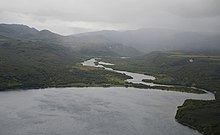
Kurile Lake is found in the southern part of the Kamchatka Peninsula,[3] in a rugged volcanic landscape.
[3] In that case, the ridge that separates the two basins may be a deposit left when earthquakes preceding the caldera-forming eruption caused Ilinsky volcano to collapse.
[8] Some islands in the lake formed by slumping and others are volcanic cones; the “Heart of Alaid” (Serdtze Alaida) is a lava dome 300 metres (980 ft) high.
[14] Ring faults, partially buried by alluvial fans and landslides, limit the caldera in the lake.
[7] Both Glinyany Peninsula and the post-caldera lava domes (Chayachii, Serdtze Alaida, Tugumynk) were affected by slumping.
Approximately 120–160 metres (390–520 ft) of sediment and volcanites bury the deposits left in the caldera by the caldera-forming eruption.
[12] The rim of the Kurile Lake caldera is best expressed at Ilinsky volcano and south and northwest thereof.
The volcanoes Diky Greben, Ilinsky, Kambalny, Kosheleva, and Zheltovsky surround Kurile Lake.
[13] Gravimetry indicates that there is still a magma chamber beneath Kurile Lake at a depth of about 4 kilometres (2.5 mi).
[5] Kurile Lake is included in the Eastern Volcanic Zone of Kamchatka, 200 kilometres (120 mi) away from the trench.
The sedimentary Paratunka Formation and the Kurilsky complex were deposited during that time; they are exposed east and southwest of Kurile Lake.
The Pauzhetka depression formed during the Pliocene or Pleistocene and was most likely accompanied by the eruption of the 300–450-cubic-kilometre (72–108 cu mi) Golygino ignimbrite.
[19] Afterwards, a resurgent dome named the Kambalny ridge formed in the Pauzhetka structure, as well as a proto-Ilinsky volcano.
During the Pleistocene, calderas, lava plateaus, and somma volcanoes like pre-Ilinsky stratovolcanoes formed in the area.
The time period between 6400 and 6600 BCE was especially active, with caldera-forming eruptions including the one that formed Kurile Lake.
Minerals contained include plagioclase, orthopyroxene, clinopyroxene, magnetite, and hornblende, in decreasing order of importance.
[25] In 1998, Kurile Lake had the highest density of brown bears of Kamchatka, and possibly of the entirety of Russia.
[4] Reports in 1923 indicate that the lake was formerly up to 50 metres (160 ft) higher than today, possibly because lava flows dammed its outlet.
[27] Fishing of the salmon of the Ozernaya River has been regulated to allow their reproduction and to conserve bear populations.
[42][43] Other volcanoes with such large eruptions during the Holocene include Baitoushan, Crater Lake and Kikai.
Subsequently, a short eruption of lapilli and pumice consisting of dacite and rhyolite occurred, most of it falling towards the northwest; their thickness reaches 20 centimetres (7.9 in) north of the lake.
[46] At this point, the vent had emerged above the water level and was generating an eruption column that deposited ash over southern Kamchatka.
[47] The ignimbrite covered a total surface area of 1,800–1,900 square kilometres (690–730 sq mi).
[16] Ash from the eruption spread west-northwest of Kurile Lake,[50] covering a total surface of over 2,000,000 square kilometres (770,000 sq mi).
[16] A minor eruption occurred at Kurile Lake between 9,000 and 10,000 years ago, resulting in the deposition of tephra north of the caldera.
A number of other lava domes and pyroclastic cones formed inside the caldera shortly after the caldera-forming eruption.
[55] Two sulfate spikes identified in the GISP2 ice core of Greenland around 6470 and 6476 BC may be linked to the Kurile Lake eruption.
[49] Close to Kurile Lake, all vegetation would have been wiped out, and deposits left by the eruption would have hampered the revegetation as well.