Mount Tambora
[4] Heavy volcanic ash rains were observed as far away as Borneo, Sulawesi, Java, and Maluku islands, and the maximum elevation of Tambora was reduced from about 4,300 to 2,850 metres (14,110 to 9,350 feet).
The first begins at Doro Mboha village on the southeast of the mountain and follows a paved road through a cashew plantation to an elevation of 1,150 metres (3,770 ft).
[13] The 16 kilometres (9.9 mi) hike from Pancasila at 740 metres (2,430 ft) elevation to the caldera of the volcano takes approximately 14 hours with several stops (pos) en route to the top.
The trail leads through dense jungle with wildlife such as Elaeocarpus, Asian water monitor, reticulated python, hawks, orange-footed scrubfowl, pale-shouldered cicadabird (Coracina dohertyi), brown and scaly-crowned honeyeater, yellow-crested cockatoo, yellow-ringed white-eye, helmeted friarbird, wild boar, Javan rusa and crab-eating macaques.
[15] Potassium levels of Tambora volcanics exceed 3 weight percent, placing them in the shoshonite range for alkaline series.
[18] Tambora has at least 20 parasitic cones[16] and lava domes, including Doro Afi Toi, Kadiendi Nae, Molo and Tahe.
[8] Inside the chamber, at depths of 1.5 to 4.5 kilometres (0.93 to 2.80 mi), cooling and partial crystallization of the magma exsolved high-pressure magmatic fluid.
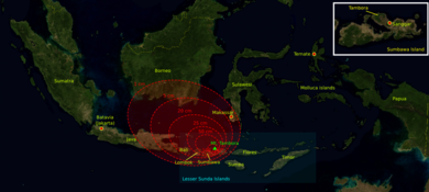
[31] A moderate-sized eruption on 5 April 1815 was followed by thunderous detonation sounds that could be heard in Ternate on the Molucca Islands, 1,400 kilometres (870 mi) from Mount Tambora.
[31] What was first thought to be the sound of firing guns was heard on 10 and 11 April on Sumatra island (more than 2,600 kilometres (1,600 mi) away),[32] and possibly over 3350 km (2060 miles) away in Thailand and Laos.
The eruption column collapsed, producing hot pyroclastic flows that cascaded down the mountain and towards the sea on all sides of the peninsula, wiping out the village of Tambora.
[31] Analysis of various sites on Mount Tambora using ground-penetrating radar has revealed alternations of pumice and ash deposits covered by the pyroclastic surge and flow sediments that vary in thickness regionally.
[31] Pyroclastic flows spread to distances of about 20 kilometres (12 mi) from the summit and an estimated 9.3–11.8 × 10¹³ g of stratospheric sulfate aerosols were generated by the eruption.
[39] The island's entire vegetation was destroyed as uprooted trees, mixed with pumice ash, washed into the sea and formed rafts of up to 5 kilometres (3.1 mi) across.
There were still on the road side the remains of several corpses, and the marks of where many others had been interred: the villages almost entirely deserted and the houses fallen down, the surviving inhabitants having dispersed in search of food....Since the eruption, a violent diarrhoea has prevailed in Bima, Dompo, and Sang’ir, which has carried off a great number of people.
It is supposed by the natives to have been caused by drinking water which has been impregnated with ashes; and horses have also died, in great numbers, from a similar complaint.
In the spring and summer of 1816, a persistent stratospheric sulfate aerosol veil, described then as a "dry fog", was observed in the northeastern United States.
[34] Along with a cooler summer, parts of Europe experienced a stormier winter,[5] and the Elbe and Ohře Rivers froze over for twelve days in February 1816.
[5] Large numbers of livestock died in New England during the winter of 1816–1817, while cool temperatures and heavy rains led to failed harvests in the British Isles.
[53] The scientists used ground-penetrating radar to locate a small buried house which contained the remains of two adults, bronze bowls, ceramic pots, iron tools and other artifacts.
[56] Based on the artifacts found, such as bronzeware and finely decorated china possibly of Vietnamese or Cambodian origin, the team concluded that the people were well-off traders.
[56] The Sumbawa people were known in the East Indies for their horses, honey, sappan wood (for producing red dye), and sandalwood (for incense and medications).
Bunyi bahananya sangat berjabuh Ditempuh air timpa habu Berteriak memanggil anak dan ibu Disangkanya dunia menjadi kelabu
Asalnya konon Allah Taala marah Perbuatan sultan Raja Tambora Membunuh tuan haji menumpahkan darah Kuranglah pikir dan kira-kira Its noise reverberated loudly Torrents of water mixed with ash descended Children and mothers screamed and cried Believing the world had turned to ash
The cause was said to be the wrath of God Almighty At the deed of the King of Tambora In murdering a worthy pilgrim, spilling his blood Rashly and thoughtlessly[12] A team led by the Swiss botanist Heinrich Zollinger arrived on Sumbawa in 1847.
As Zollinger climbed, his feet sank several times through a thin surface crust into a warm layer of powder-like sulfur.
Because of the length of the distance to be travelled on foot, the partly very high temperatures and the lack of water it was a particular challenge for the team of Georesearch Volcanedo.
From their accounts, they started their journey in a "fairly barren, dry and hot country", and then they entered "a mighty jungle" with "huge, majestic forest giants".
In between the hunting ground and the logging area, there is a designated wildlife reserve where deer, water buffalos, wild pigs, bats, flying foxes and species of reptiles and birds can be found.
People had reached the caldera floor only in a few cases as the descent down the steep wall is difficult and dangerous, subject to earthquakes, landslides and rockfalls.
The size of the cautious area is 185 square kilometres (46,000 acres), and includes Pasanggrahan, Doro Peti, Rao, Labuan Kenanga, Gubu Ponda, Kawindana Toi and Hoddo villages.