Kuroshio Current
[1][2][3] Additionally, the current's significant nutrient transport results in a biologically rich ecoregion supporting an important fishing industry as well as diverse marine food webs.
The South China Sea for example has relatively low nutrient concentrations in its upper waters, but experiences enhanced biological productivity due to the input from the Kuroshio Current Intrusion.
[5] It was discovered in 1565 by Andrés de Urdaneta, a native of Guipuzcoa, colonial administrator, supervisor of nautical expeditions, corregidor, Augustinian monk and loyal navigator in the service of King Philip II, when, aboard the nao San Pedro, he was the first to open the "tornaviaje" between Cebu (Philippines) and the coasts of Old California (New Spain).
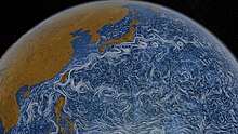
The Kuroshio is a relatively warm ocean current with an annual average sea-surface temperature of about 24 °C (75 °F), is approximately 100 kilometres (62 mi) wide, and produces frequent small to meso-scale eddies.
[6] East of Taiwan, the Kuroshio enters the Sea of Japan through a deep break in the Ryukyu island chain known as the Yonaguni Depression.
[9] The Kuroshio Current is the Pacific analogue of the Gulf Stream in the Atlantic Ocean,[10] transporting warm, tropical water northward toward the polar region.
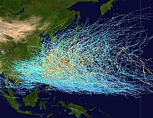
[11] The majority of typhoons occur from July through October during northern hemisphere summer,[11] and typically form where the Kuroshio Current is the warmest near the equator.
It has been proposed that lower sea-level and tectonics may have prevented the Kuroshio from entering the Sea of Japan during the last glacial period, approximately c. 115,000 – c. 11,700 years ago, and remained entirely within the Pacific basin.
[16] However, other proxies and ocean models have alternatively suggested that the Kuroshio path was relatively unaltered,[17][18] possibly as far back as 700,000 years ago.
[19] The magnitude of the Kuroshio Current and seafloor bathymetry results in deep sea erosion and sediment transport in multiple regions.
Some of these fine sand particles have settled into a dune field while the remaining sediment is transported and deposited throughout the region by the Kuroshio Current.
The current transports significant amounts of nutrients to support this primary production from the East China Sea continental shelf to the subarctic Pacific Ocean.
In addition, the Kuroshio is classified as a biodiversity hotspot, meaning the waters circulating through the region are host to many different species, yet many of its resident organisms are at risk of becoming endangered or are already at the brink of extinction as a result of local and/or global human activity.
Warm sea surface temperatures and low turbidity in the region lead to clearer waters which allows for deeper penetration of sunlight and an extension of the epipelagic zone.
[30][31] During these events, dust clouds transport and deposit phosphate and trace metals which subsequently stimulate growth in both Prochlorococcus and Synechococcus as well as diatoms.
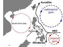
[34] This upwelling event, the Kuroshio Current intrusion through the Luzon Strait and South China Sea, and summer monsoons, represent the convergence of a multitude of oceanic waters of different origin.
[38] Like copepods and diatoms, tunicates, specifically salps and doliolids, also play an important role on the biogeochemical cycle as well as on the food web in the Kuroshio.
Baleen whales for instance, make use of the current's transport of Japanese sardine and jack mackerel larvae to their feeding grounds in the north pacific.
The summer spawning is in another part of the East China Sea, from which the larvae are entrained into the Tsushima current that flows north between the islands of Japan and the mainland.
In fact, studies have reported that annual catches in Japan have gradually increased since the late 1980s and it has been proposed that changing environmental conditions have caused the autumn and winter spawning areas in the Tsushima Strait and near the Goto Islands to overlap.
[51] The availability of Japanese sardines and mackerel eggs, larvae, and juveniles are the baleen whales' primary food sources in these areas.
The Kuroshio Current plays an important role in influencing regional climate and weather patterns mainly through the input of warm waters from lower latitudes northward into the western edge of the Pacific basin.
[1] The climate of many Asian countries has been affected by the distribution of heat by these processes for millions of years, changing wind patterns, precipitation, and mixing warm tropical waters into the Sea of Japan.
The contrast between the temperatures of these stratified vertical layers can be discernable such that the lateral advection of mode water can be traced for thousands of kilometers.
[57] Mode water formation is variable and largely dependent on the flow intensity of the Kuroshio Extension and atmospheric heat flux efficiencies.
In addition, the general observed southward migration of both the NEC and SEC subcurrent bifurcation latitudes over the past thirty years has been consistent with a strengthening of western boundary currents.
With shifting winds and increased gyre circulation in conjunction with a "business as usual" anthropogenic carbon input scenario, bifurcation latitudes are predicted to continue on poleward migrations into the future, contributing to the intensifying Kuroshio Current.
As the Kuroshio flows northeastward from northeast of Taiwan along the shelf slope of the Eastern China Sea, it carries Jack Mackerel eggs and larvae to southern Japan and Honshu Island.
[68] Minamisanriku had most of the town's port and aquaculture facilities restored by 2014, and as of 2018, reconstruction of key infrastructure in the prefectures of Iwate and Miyagi was near completion.
[69] Local Japanese fishing fleets hauled 5,928 tons of seafood product valued at over 2.21 billion yen (19.342 million U.S. dollars) in 2021.