La Palma
La Palma has an area of 708.32 square kilometres (273.48 sq mi) making it the fifth largest of the eight main Canary Islands.
Its highest mountain is the Roque de los Muchachos, at 2,426 metres (7,959 ft), being second among the peaks of the Canaries after the Teide massif on Tenerife.
The northern part of La Palma is dominated by the Caldera de Taburiente, with a width of 9 km (6 mi) and a depth of 1,500 m (4,921 ft).
Beyond Punta de Fuencaliente at the southern tip of the island, the Cumbre Vieja continues in a southerly direction as a submarine volcano.
[16] Hector Izquierdo Triana, born in La Palma and secretary of state for finance at that time, was appointed to this responsibility.
[17][18] In an episode of the BBC Horizon series broadcast on 12 October 2000, two geologists hypothesised that during a future eruption, the western flank of Cumbre Vieja, with a mass of approximately 1.5 x10¹⁵ kg, could slide into the ocean.
[19][20] The claim was also explored in a BBC docu-drama called End Day which went through several hypothetical scenarios of disastrous proportions.
[22] Other experts agree that the fracture resulting from the 1949 eruption is a shallow and inactive surface expression that should be monitored, but consider the possibility that it is unstable as being almost nonexistent.
[24] In 2006 Jan Nieuwenhuis of Delft University of Technology simulated several volcanic eruptions and calculated it would take another 10,000 years for the flanks to become sufficiently high and unstable to cause a massive collapse.
For continents, the worst effects would be expected in Northern Brazil (13.6 m), French Guiana (12.7 m), mid-US (9.6 m), Western Sahara (largest prediction at 37 meters) and Mauritania (9.7 m).
While still large, this would not qualify as a megatsunami (apart from locally in Macaronesia), with the highest prediction for Western Sahara comparable to the 2011 Japanese tsunami.
As altitude increases moving inland, the climate becomes cooler and more humid, which provides conditions for laurisilva cloud forests to occur, such as the one in the Natural Park of Bosque de los Tiles.
The island is divided into 14 municipalities: La Palma has a "sister city" relationship with El Dorado Hills, California.
Fishermen operating from Santa Cruz de La Palma, Tazacorte, and Puerto Naos catch fish for the local markets.
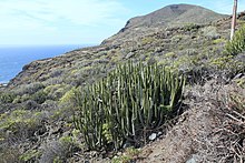
The pine forests are also home to two recently discovered and extremely rare La Palma endemics: Lotus eremiticus and L. pyranthus.
Cytisus supranubius, a white-flowered broom known locally as Retama del Teide, is native to La Palma and Tenerife, being restricted to the alpine/subalpine habitats present only in these two islands.
Echium webbii, a branched shrub with several smaller, dark blue flower spikes, is another island endemic with close relatives on Tenerife.
Other La Palma endemics include members of the daisy family, such as Sonchus palmensis, Argyranthemum haouarytheum Pericallis papyracea and Cheirolophus sventenii.
[40] The official natural symbols associated with La Palma are the red-billed chough (graja) and Pinus canariensis (Canary Island pine).
The main remnants of this culture are their cave dwellings, enigmatic petroglyphs and paved stone paths through the mountains.
The Genoese navigator Lancelotto Malocello reached the archipelago in 1312 and remained for two decades until expelled by a native uprising.
The conqueror of La Palma was Alonso Fernández de Lugo, who defeated Tanausu, the last king on the island.
There is also ferry service between the city of Santa Cruz de La Palma and the islands of Tenerife and Gran Canaria.
La Palma receives almost all of its water from the mar de nubes (sea of clouds) of the northeast trade winds.
Due to the location of the island and the height of its mountains, some 2,400 m (7,874 ft) above sea level, a number of international astronomical observatories have been built on the Roque de los Muchachos.
[45] The 2024 Netflix original series La Palma is inspired by the disproved theory[21] about possible catastrophic events[19] that could happen on the island.