Cumbre Vieja
[4] The spine of Cumbre Vieja trends in an approximate north–south direction, comprising the southern half of La Palma, with both summit ridge and flanks pockmarked by dozens of craters and cones.
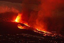
[5] The latest eruption began on 19 September 2021 in a forested area of Las Manchas locality known as Cabeza de Vaca.
Voluminous lava flows quickly reached populated areas downslope, fanning out across settlements and banana plantations, destroying thousands of buildings and ultimately pouring over steep cliffs into the ocean to enlarge the island at several locations.
[9][10] It is hypothesised that this structural reorganisation is in response to evolving stress patterns associated with the development of a possible detachment fault under the volcano's west flank.
There is no evidence beyond its surface expression that the 1949 section of the rift extends in a north–south direction, nor that there is a developing detachment plane.
During the eruption on 1 and 2 July, two strong earthquakes with an estimated intensity of VIII on the Modified Mercalli Scale also occurred, the epicentre was calculated to be near Jedey.
It was traceable to the Hoyo Negro and Duraznero vents, making a total length of about two and half kilometres or about 1/10 of the exposed length of the Cumbre Vieja, and parts of the western half of the Cumbre Vieja ridge had apparently moved about 1 metre sideways and 2 metres downwards towards the Atlantic Ocean.
During the following years periodic seismic activity occurred, but due to the absence of monitoring equipment, the only reports are those recorded in the media.
On 10 July the westward flow of lava from the Llano del Banco vents reached the coast at Puerto de Naos and entered the Atlantic Ocean, forming a lava delta, the velocity is estimated at ~14 metres (approximately 46 feet) per sec.
Only residual fumarolic activity and thermal emissions then occurred until 30 July when the Duraznero vent and fissure re-activated.
[1] The process creating the earthquakes of 1 and 2 July is considered to have been driven by the pressure caused by the rising magma super-heating water trapped within the edifice of the volcano.
[6] The role of Special Commissioner for the Reconstruction of the island of La Palma was created in 2022 to coordinate and promote the actions adopted by the General State Administration to repair the damage caused by volcanic eruptions and for the reconstruction of the island of La Palma.
[26] Hector Izquierdo Triana, born in La Palma and secretary of state for finance at that time, was appointed to this responsibility.
The authors of the paper also said that the geological development of La Palma had undergone changes due to the southerly migration of the hotspot and the collapse of the earlier volcanoes.
In October 2000, the British Broadcasting Corporation (BBC) transmitted a Horizon programme called "Mega-tsunami: Wave of Destruction",[29] which suggested that a future failure of the western flank of Cumbre Vieja could cause a megatsunami.
It painted a scenario in which the western flank of the Cumbre Vieja had collapsed and the initial wave had an amplitude of about 1,000 metres.
Computer modelling indicates that the resulting initial wave may attain a local amplitude (height) in excess of 600 metres (2,000 ft) and an initial peak-to-peak height[clarify] that approximates to 2 kilometres (1 mi), and travel at about 720 kilometres per hour (450 mph) (approximately the speed of a jet aircraft), inundating the African coast in about one hour, the southern coastlines of the British Isles in about 3.5 hours, and the eastern seaboard of North America in about six hours, by which time the initial wave will have subsided into a succession of smaller ones each about 30 metres (100 ft) to 60 metres (200 ft) high.
Studies of possible local 'mega-tsunamis' in the Hawaiian Islands draw distinctions between the tsunami wave periods caused by landslides and subduction-zone earthquakes, arguing that a similar collapse in Hawaii would not endanger Asian or North American coastlines.
The debris flows are now considered to be a normal process where a volcano sheds some proportion of excess material and thereby makes itself more stable.
Moore (1964)[34] was the first geologist to interpret such features depicted on a United States Navy bathymetric chart.
Moss et al. (1999)[35] reported that the western flank of La Palma is static and there is no indication that it has moved since 1949, confirming the dimensions provided by Bonelli-Rubio (1950).
[14] Carracedo et al. (2001)[36] state that they consider the crack to be a surface expression which is of a shallow and inactive nature.
Approximately 5 x 10⁹ m3 (6.5 x 10⁹ cu yd) of material—about two orders of magnitude less than the claimed mass of the Cumbre Vieja—generated a landslide which entered the ocean and generated a westerly-directed tsunami.
Scientists at TU Delft in the Netherlands reported in 2006, that the section of the western flank of the Cumbre Vieja that was conjectured as potentially failing and falling into the Atlantic Ocean to create the hypothesised La Palma mega-tsunami was both too small in mass and volume, and far too stable to break away within the next 10,000 years.
[42] A 2008 paper by Løvholt et al. looked into this very worst-case scenario, the most massive slide that could happen (though unlikely and probably impossible right now with the present day geology).