La Pita
La Pita was discovered when an access road was being built, the workers and owners of the land descended towards Río Minero and noticed a yellowish patch of earth accompanied by the black carbonate altered shales of the Muzo Formation.
The entrance of the mine was first opened in a ravine at the bottom of the mountain near Río Minero and extends approximately 500 metres (1,600 ft) until the tunnel makes contact with the principle fault line running through the length of the La Pita property.
Recently, La Pita had entered into an agreement with a publicly traded company, FURA Emeralds Inc.[1] This has since been terminated.
In 2016, a third company was entering into agreements for full operation at La Pita Mine and to acquire a stake in Zuliana De Esmeraldas Ltda.
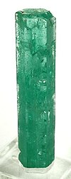
There appears to be a periodicity to the occurrence of variable thickness (1 to 30 centimetres (0.39 to 11.81 in)) calcite veins (observed between 070/35 and 320/65 orientations), that are the primary target for emerald production.
Where these secondary fractures intersect with the primary vein orientation, anecdotally it has been observed that there appears to be an improvement in both quality (colour and clarity) as well as, sometimes, quantity/size.
Muzo Formation (K1m - Hauterivian-Barremian age), outcropping in the sector of Las Pavas, Peñas Blancas, Coscuez, also appears in Vélez, Chiquinquirá and La Palma.
In the region of Muzo and Calcetero, the formation is also part of the syncline of El Almendro and forms the nucleus of the Pauna Anticlinal.
[3] In the upper part, intercalations of black shale with gypsum flakes and abundant pyritic micritical concretions appear, some with ammonites.
[4][5] The La Pita concession agreement is active and registered with the National Mining Agency of Colombia.
The mining region, despite its poor reputation is actually safe and community orientated, the violence is now a faint memory of the past.